

Myles Zhang
View publications by category:
200+ Posts
architecture of fear British history building construction car culture cathedral construction sequence Chinatown collection data visualization Detroit dissertation project drawing Eastern State Penitentiary essay film historical GIS historic preservation history of technology medieval history models Newark Newark art Newark history New York City NYC art NYC history NYC photography panopticon pastel photo-essay photography planning politics pop-up cities prison history program application essays proposals for architecture protest public speaking rail travel ruins sounds of the city time-lapse cartography walking watercolor waterfront
Tag Archives: ruins
No comments
The Detroit Evolution Animation
Created in gratitude to the University of Michigan’s PhD program in architecture
Related: The New York City Evolution Animation
.
.
This film traces Detroit’s evolution from its origins as a French trading post in the 1700s, to its explosion as a metropolis, followed by its precipitous decline as a symbol of America’s post-industrial urban landscape. The film weaves in details about the city’s politics, population, and technology – all of which influenced the city’s geography and built environment. At each phase in urban history, the built environment grew and was modified in direct response to political events like racial segregation, population changes like the Great Migration, technology developments like the mass-produced car, and government interventions like urban renewal.
The animation tells the story of Detroit specifically and the story of American cities more broadly. To varying degrees, the path of Detroit’s development mirrors hundreds of other smaller cities and towns scattered across the American Northeast and Midwest. No other American city witnessed as large a population loss, as dramatic 1960s racial unrest, or as radical a transformation from symbol of progress into symbol of decay. To a lesser degree, other places in America followed Detroit in lockstep. Urban renewal projects, highway construction, racial tensions, suburban growth, and infrastructure under-investment happened across America, and in parallel to Detroit.
However, the most dramatic transformation of Detroit is left unwritten in this film. Beneath the surface-level events of political conflict and urban change, the largest event in Detroit is not unique to Detroit. As filmmaker Godfrey Reggio describes, the most important theme in the history of civilization is “the transiting from all nature, or the natural environment as our hosts of life for human habitation, into a technological milieu into mass technology as the environment of life.” European cities developed slowly and gradually over centuries, in the process removing all memory of the natural landscape before civilization. American cities are unique in their youth and speed of growth. They are new enough that an active memory survives through place names and written records of the landscape and indigenous peoples who lived there before colonization. As the oldest colonial settlement west of the Appalachians, and as the city that perfected the mass-produced automobile, Detroit becomes the prime symbol of man’s transformation of his home from a natural world into a technological society removed from nature.
View map bibliography and project methodology
Includes links to download all source files on which the film is based
.
The accompanying music is by composer Philip Glass and was written for Godfrey Reggio’s 1982 experimental documentary Koyaanisqatsi. The shifting layers and repetitive phrases of Glass’ music accompany Reggio’s montages of natural landscapes, factory assembly lines, and chaotic city streets. Koyaanisqatsi means “life out of balance” in the language of an indigenous American tribe called the Hopi. In the original documentary, Glass’ music was paired with scenes of desolate streets in the South Bronx, the abandoned Pruitt-Igoe public housing in St. Louis, and ruined skyscrapers falling in slow motion. In my reinterpretation of Glass’ music, the imagery is now of Detroit in maps. The pace and events in the animation are tied to the structure of the music. As the volume and speed of the music increase and decrease, so too does the growth and decline of Detroit.
View music in original context
Pruit Igoe from Koyaanisqatsi; composed by Philip Glass with images by Godfrey Reggio
.
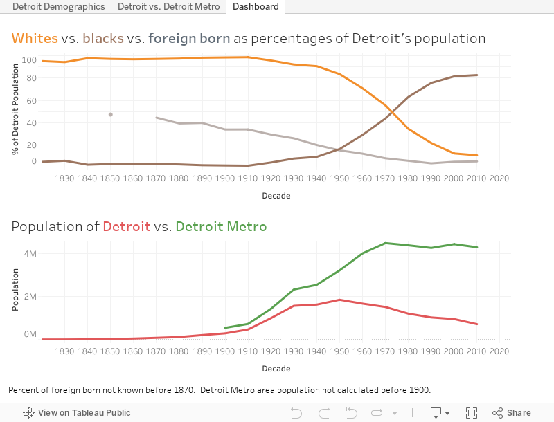
Population Changes to Detroit Over Time
Hover over infographic for details of each census year.
.
The influx of Black people during the Great Migration and the outflow of cars from Detroit’s factories reshaped the city’s built environment and the American public’s perception of Detroit. Detroit is now thought of as a majority-Black city surrounded by majority-White suburbs. Today, 83% of Detroit’s population is Black, and only 11% is White. But the graph above shows that Detroit was majority-White until the 1980 census. For most of its history, Detroit was 95 to 99% White. Today, the majority of the metro region’s population lives in the suburbs that surround Detroit. But until the 1960 census, the majority of the population lived within the city limits. Today, Detroit is so reliant on the car that it has no commuter rail network, no subways, and limited public transportation options. But until the 1950s demolition of Detroit’s light rail network, a majority of residents lived within walking distance of a light rail station for commuting. Detroit’s demographics, suburban sprawl, and transportation options have all flipped in the past century. From a high-density, transportation rich, and majority-White city in 1920, Detroit has become a low-density, transportation poor, and majority-Black city in 2020.
A lot of people say Detroit has terrible public transit design. But from the perspective of car companies, the real estate lobby, and fearful Whites, the system does exactly what it was intended to do: to segregate and divide our country by covert means long after Jim Crow officially “ended.” Failure by design. The failure of Detroit is, in large part, planned and a consequence of government policy decisions that: prioritize suburban growth over urban development; benefit suburban Whites over urban Blacks; and encourage private cars at the expense of public transit.
As the Detroit Evolution Animation plays, the map key on the lower right hand corner indicates Detroit’s demographics at each decade in history. Try to link changes to demographics with changes to the urban form. Ask yourself the questions: How were technology, transportation, and demographic changes imprinted on the built environment? How does the built environment, in turn, shape urban and suburban life?
.
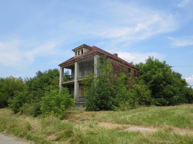
Decaying home near Detroit’s abandoned Packard Automotive Plant
The Vanishing City of Newark
Vanishing City is a visual documentary about architecture and redevelopment in Newark.
I am witness to the poetic decay of my city’s cultural heritage. An abandoned barge sinks in murky waters. A former factory tumbles before the wrecking ball. A sea of weeds lays siege to a vacant home. An empty lot is a gaping hole, a missing tooth, in the urban body. As a wall crumbles to the ground, a tree, anchored to the wall, reaches for the sky. While my city’s industrial past succumbs to demolition, new buildings grow from old lots.
Behind this slow decay, there is a hidden beauty in the transient. It is the realization that what was built to last forever will not last. It is the expectation that the destruction of the past could contain the seeds of a better city. The ruin forces the viewer to imagine and reconstruct what was there in ways the restored building does not.
Will the monuments we erect to culture and capitalism endure? The ruins of the Athenian Acropolis became a symbol for democracy. Could the same fate await our society’s equivalent forums, the strip mall, grocery store, and drive-thru? Will we be good ancestors?
My transient urban environment compels me to examine and re-examine my sense of place before it vanishes from memory.
.
 Edited")
Newark Broad Street Station

Murphy Varnish Factory

Polhemus House demolition

Pulaski Skyway

Pulaski Skyway

Penn Station Newark drawbridge

Port Newark tire yard

Port Newark freight yard

“Revitalization” of Baxter Terrace

City in transit

Roman ruins

Progress Inc.

Progress Inc.

Pulaski Skyway

Polhemus House demolition

Polhemus House demolition

Westinghouse demolition near Newark Broad Street Station

Waiting for demolition at the “Little Annie Drawbridge”

Last Sunset

Downtown Newark

Rusting barge
.

Baxter Terrace Projects

Illegal Demolition

Baxter Terrace Projects

Neighborhood resident Angel and his dog Tigressa stand before Murphy Varnish

Illegal Demolition

Polhemus Home

Polhemus Home

Polhemus Home

Polhemus Home

Rubble in 2009

The Chimney Falls – 2008
")

")


.
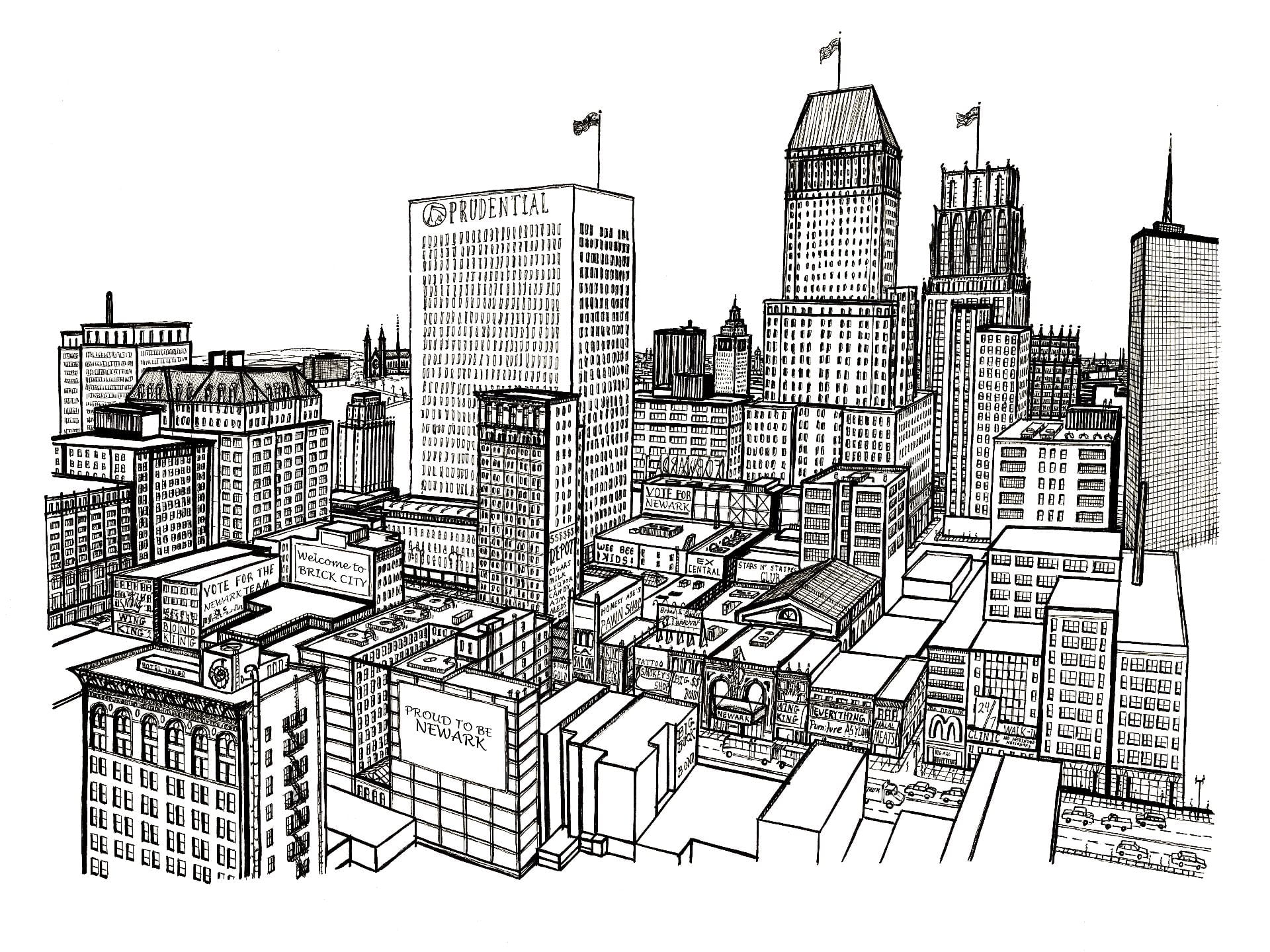
Downtown Newark
.
Newark Broad Street Station
Newark Metamorphosis
A story of urban change told through picture postcards
.
Developed in collaboration with the Newark Public Library
for a summer 2018 exhibition on the history of Newark’s built environment
.
.
An interactive map and photo project about Newark past and present, 1916 and today
Over the past century, Newark lost much of its architectural heritage and urban fabric. Along with cities like Chicago, Camden, and Detroit, Newark’s built environment evolved in response to population loss, urban renewal, and suburban growth. Explore the changing face of Newark in this interactive map with 150 comparative views of past and present streetscapes.
All historic images in this series are selected from the Newark Public Library’s collection of c.1916 postcards. All new photos were taken in 2016 to commemorate the 350th anniversary of Newark’s 1666 founding. My images capture Newark around 1916, at a moment just before American cities entered the automobile era. Postcards were a medium of communication popular in the early twentieth century. Many postcards feature views of Newark’s important landmarks; others are of mundane street scenes and structures. Through color corrections, careful editing, and marketing, these postcards present a curated and idealized view of Newark as postcard artists, business owners, and city planners desired the city to be remembered.
.

Trouble navigating map? Watch video tutorial below. | View all images on a single page. | Spot a mistake? Contact Myles.
A city is more than its monuments, skyscrapers, and grand civic architecture. A city is a collection of structures, small and large, wood and stone, humble and grand. Newark has preserved its large monuments but has not maintained the cultural and urban fabric of its tenements, wood frame houses, warehouses, and single-family homes. Individually, these small-scale structures are humble and unimportant. Yet collectively, they constitute the living fabric of the city. Too many have been demolished in the name of progress, creating a cityscape radically different from the city’s height in the early twentieth century. For a short video about Newark’s evolving neighborhoods click here.
.
Launch map and read essay about urban change.
.
Related Projects
.
Newark, a century after 1916
.
Downtown Newark in 1912 and in 2016. Note how the building at right, under construction in 1912, is now abandoned in 2016.
.
Prudential Insurance headquarters (left) and the City Post Office (right) c.1916. Both now demolished.
.
Prince Street in 1916 and 2016. The complete and total loss of a neighborhood.
.
Drawing by Winsor McCary from a 1928 article “Newark 58 Years from Today” shows a futuristic city that never came to be.
.
Launch map and read essay about urban change.
Murphy Varnish Lofts in Newark
Murphy Varnish, built in 1886, is one of Newark’s oldest factories still standing. Its brick walls, terracotta ornament, and intricate brickwork reflect a time when industrial structures were more than just functional. Murphy Varnish reflects a time when industry was central to Newark’s wealth and key to its future success. It is a monument to industry, built to last (and landmarked since 1979 by the National Park Service). Recent renovation efforts promise to turn this derelict structure into a community of apartments.
The summer after my first year at Columbia University, I had the privilege of working with the Studio for Urban Architecture & Design (SUAD), the architects hired to redevelop this derelict factory into about forty residential units. During my time at SUAD, I observed firsthand the workings of a small architecture firm and the inspiring conversion of an old factory into something viable and living. As my internship neared its end, I photographed the historic factory and created a detailed watercolor drawing of the finished renovation.
During these three months, I learned that architecture is more than the creation of art and beauty for their own sake. It is a tool to build a stronger city through improving the built environment. For decades, Newark has seen architecture that does not value aesthetics or connect with the city’s rich history. Prefab, cookie-cutter homes are often built in Newark; they are out of place and context. These kinds of projects are set back from the street with little more than driveways and vinyl siding for the streetscape. Corporate monolith towers rise in the downtown; through catwalks and perimeter fences, their occupants need not engage with the city. Every morning and every evening, they can ride to and from Newark without setting foot outdoors or on city streets. For historic preservationists, much of the city’s old architecture was lost to parking lots, urban renewal, and urban blight.
In this context, Murphy Varnish is an exceptional outlier. In a city once home to thousands of small factories, Murphy Varnish is one of the few that remain. Old Newark maps show dozens of factories surrounding Murphy Varnish. In the past few decades, almost all of these industrial structures were demolished and replaced with empty lots and low-quality prefab homes. Now, Murphy Varnish stands alone in a residential neighborhood; it is a unique reminder of history that becomes all the more worth saving.
As I begin my second year of college, I return to campus with renewed appreciation for historic preservation. I return with deeper admiration for the tireless efforts of Newark activists and architects to preserve the city’s rich architectural heritage for future generations.
This project was made possible by a summer grant from Columbia’s Center for Career Education.
.
Murphy Varnish before work began
.

Neighborhood resident Angel and his dog Tigressa stand before Murphy Varnish

Murphy Varnish company trademark

Abandoned building on nearby NJ Railroad Avenue

This industrial land was condemned before construction was complete.

Murphy Varnish among empty fields and shoddy boxes

Murphy Varnish

Pedestrian passes by Murphy Varnish.

Bargain or Scam?

Angel

NO TRESPASSING GUARD DOG

248.5 Chestnut St.

Boxes and empty lots
.
A work in progress

Demolition

Emaciated tree trunks embedded in the factory’s perimeter fence

Fourth floor renovation

Third floor renovation

View from factory to Downtown Newark

Round window to Downtown Newark

Up the chimney
.
The finished conversion
Watercolor rendering of completed project
Pictures of Newark
.
As a lifelong citizen of Newark, I spent much of the past few years painting and photographing my changing city. Pictures features a selection of my work, complemented by classical music. Five of Modest Mussorgsky’s pieces from his composition Pictures at an Exhibition are selected, each of which represents the feel of a certain part of Newark. The following five locations are featured:
1. THE PASSAIC RIVER – music: Mussorgsky’s Promenade
2. OLD ESSEX COUNTY JAIL – music: With the Dead in the Language of Death
3. MOUNT PLEASANT CEMETERY – music: Promenade
4. DOWNTOWN NEWARK – music: Mozart’s Death March (k 453a)
5. PORT NEWARK – music: Promenade
Growing up in Newark, I am inspired and saddened by the inner city. I am inspired by Newark’s hope of renewal after decades of white flight, under-investment, and urban neglect. I am saddened by the loss of my city’s historic architecture and urban fabric to the wrecking ball of what is called progress.
Curious about the history of the old Essex County Jail? Explore this interactive exhibit.
.
Featured work from this film

Newark Broad Street Station

Roman Ruins

Essex County Jail

Old drawbridge at Port Newark

Rusting barge


Downtown Newark

A sense of scale

Craneway Street

Symmetrical bridges cross the Passic River

Port Newark

Gulf Station

Corbin Stret


Essex County Jail

Sunset on the Passaic River

After hours in Port Newark

Pulaski Skyway

The Chimney Falls – 2008

Industrial zone in the New Jersey Meadowlands

Waiting for demolition at the “Little Annie Bridge”

Big tires, bigger nation

Waiting for demolition at the “Little Annie Drawbridge”

This way to freedom

City in autumn
Renaissance City
Growing up in Newark, I was inspired and saddened by my inner-city environment: I am inspired by Newark’s hope of renewal after decades of white flight, under-investment, and urban neglect. I am saddened by the loss of my city’s historic architecture and urban fabric to the wrecking ball of ostensible progress. My Renaissance City photo and art series depicts the Newark of my childhood with garish signage and decayed structures blanketing my city’s architecture in a medley of color and consumerism.
Click here to see a film featuring more of my Newark-based artwork.
.
Urban decay in Newark to the tune of Mozart’s death march (k 453a)
Urban Garden in Newark
By Maia and Myles Zhang
.
In time, we will wind our way and rediscover the role of architecture and man-made forms in creating a new civilized landscape. It is essentially a question of rediscovering symbols and believing in them once again. […] Out of a ruin a new symbol emerges, and a landscape finds form and comes alive.
– John Brinckerhoff Jackson, A Sense of Place, A Sense of Time (1994)
.
In the past 60 years, my home city of Newark, NJ has lost 40% of its population and nearly 50% of its buildings.
The timely and needed development of Newark’s land is prevented through a combination of flawed government policy, economic downturns, risk-averse landowners, and lax enforcement of land use laws. As a result, hundreds of acres of prime urban land remain undeveloped as vacant parking lots. There are over 300 acres of paved surface parking lots in my neighborhood (link to interactive parking map). This sub-optimal and low-density land use has consequences for city government (undeveloped lands are taxed less), housing (Newark has a shortage of quality affordable housing), and the environment (parking lots burden the city’s sewer system with surface runoff). American cities are unique in the world for being so built around, and effected by, the car.
One of Newark’s larger vacant parcels was an electric factory and has sat empty for nearly 40 years — 25 years as a decaying warehouse and 15 more years as wasteland filled with yellow crabgrass and decomposing trash. For five years, rusting demolition equipment and a towering pile of brick, steel, and construction debris moldered in the center of the lot — visible to the millions of commuters who pass this site yearly, watching day by day as the building gradually deteriorated into weeds.
Then our family decided to experiment with ways to bring a semblance of new life to this tired soil: a garden. Our proposal to cover this raw earth in spring flowers was denied by the site’s owner, who was afraid community access would weaken his ownership stake as an absentee landlord. Undeterred, on a quiet weekend with few commuters passing by, we slipped behind the barbed wire fence to sow under the smiling sun. The wondrous flower mixture danced out of the plastic seeder, humming a soothing rhythm. Thanks to more nourishing rain, hope germinated from the infant seeds. Soon, sprouts began popping up hesitantly. At first, the green shoots looked no different from the weeds, but with time they grew taller and flowers bloomed — clover, sunflowers, daisies, and Queen Anne’s Lace. Where once commuters walked pass, now they would stop and take photos of our work, with the city skyline rising in background.
Every June, the sanitation workers come with their oily machines and sweaty equipment to level the land of the flowers we planted. With hatchets, they destroy the flowering fruits of our labor and re-expose the rubble strewn dirt. With chainsaws, they chop down the trees that sprout from the chain-link fence. They leave the mauled flowers and trees strewn on the ground where they fall. Over the following weeks, the flowers and leaves dry in the hot sun and return to the dusty earth tones of the dirt from which they sprang. However, each new year, the flowers return more resilient than before, and with more numerous and larger blossoms. In earlier years, the seeds’ return required our help and gentle watering. These days, they return unaided, attracting the occasional bird. The cycle repeats… “Where flowers bloom, so does hope.”
.
Learn more about this project on GoFundMe.
Read more about Newark’s urban decay.
This project was also featured in the spring 2018 edition of Sine Theta magazine.
.
Westinghouse demolition
.
Westinghouse demolition near Newark Broad Street Station
.

The Wesinghouse before demolition

The Westinghouse in the 1940s

“On Top” painting by Maria Mijares in 2008

Rubble in 2009
.
The chimney falls
.
Newark Broad Street Station
.
Now an urban garden
.


Rome: The Eternal City
 .
.
 .
.
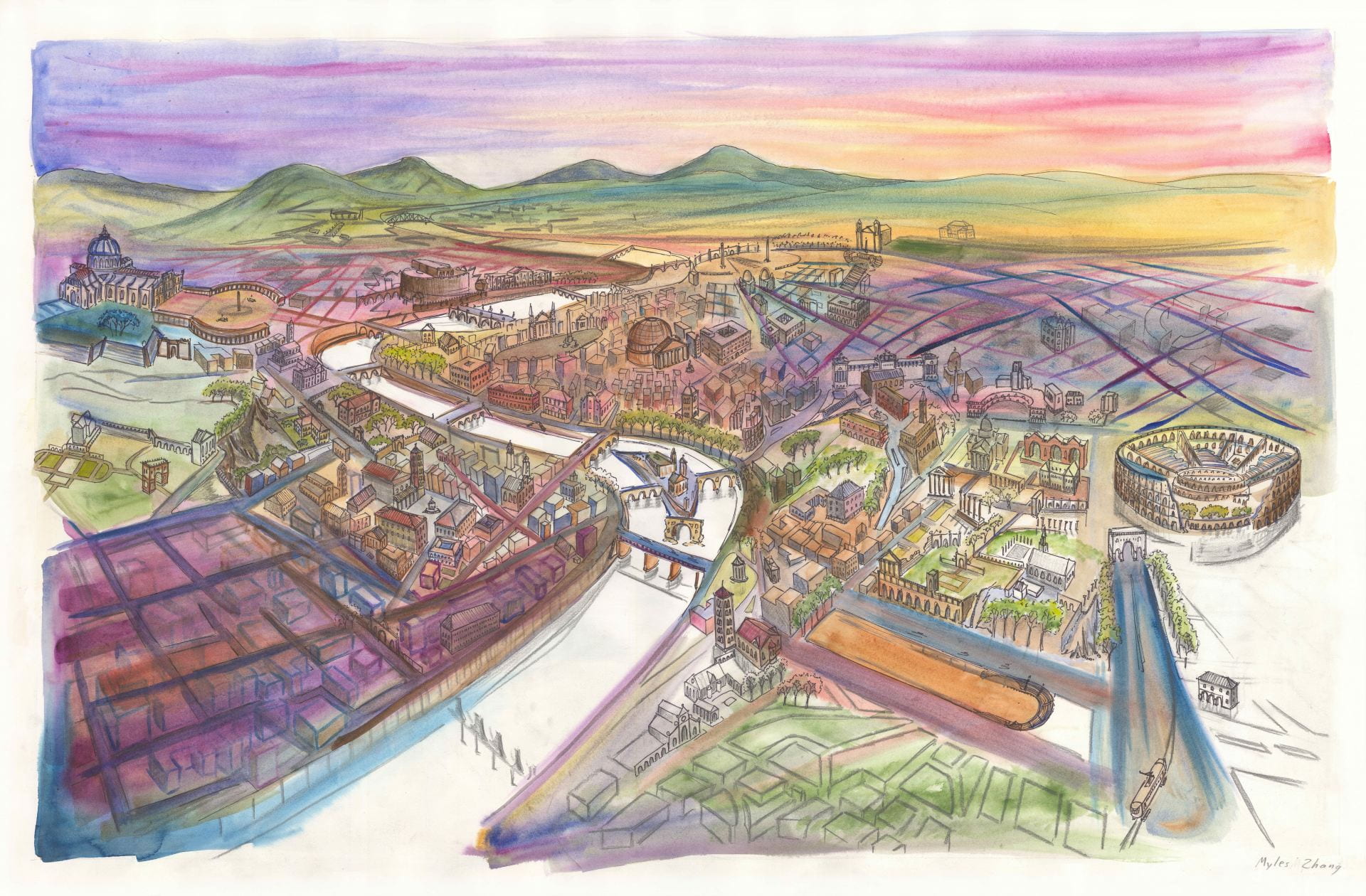
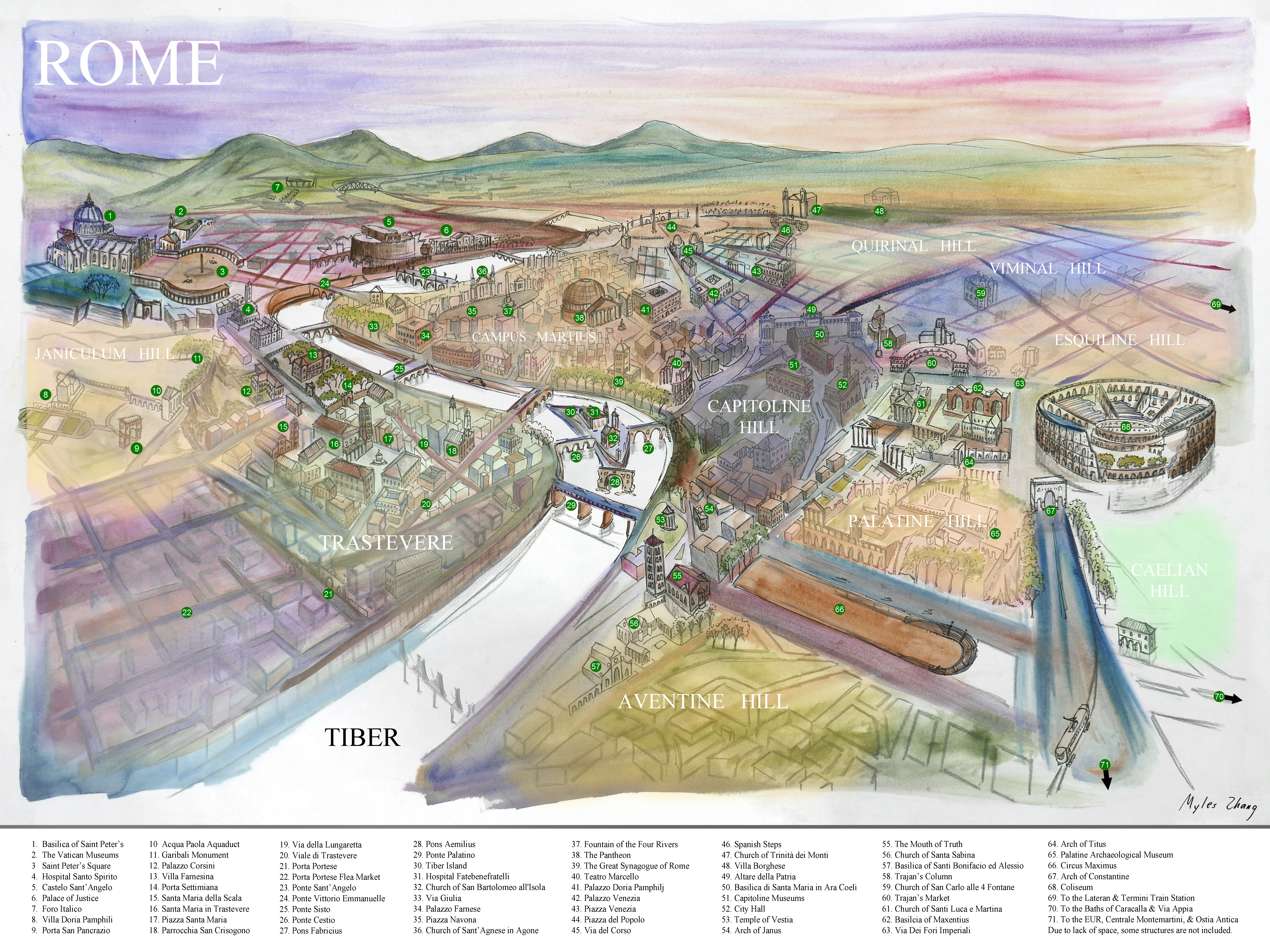
Rome, the Eternal City, the city of a thousand jeweled churches. Each church a treasure trove of glistening gold and baroque drapery cascading over its roof and walls. Each street a channel to and from some unexpected street side treasure: A Roman coffin turned public fountain, a marble column turned city wall, or a dark alley where the sound of water drips eternally. Rome is the city of reinvention with each subsequent structure built on the physical and symbolic history of Greece, Rome, the Middle Ages, the Renaissance, and the modern era.
Physicist Isaac Newton once proclaimed that: “If I have seen further, it is by standing on the shoulders of giants.” Rome, too, can remind herself that: If I stand more powerful and majestic, it is not thanks to current accomplishment but to the bedrock of history that accumulates treasures through time and value through age. Rome, too, stands “on the shoulders of giants:” The Roman Empire gave Rome her aqueducts and temples, the Renaissance gave Rome her churches, and the hand of Mussolini gave Rome her fascist monuments and boulevards sliced through the urban core.
Despite being grounded in history, Rome is very much a city of the present. The human fabric of this city may have left the urban core with waves of gentrification and tourism, but the spirit of a living and breathing city endures. North African immigrants peddle their umbrellas and selfie-sticks in the shadows of the Coliseum. Mass with the Pope continues in Saint Peter’s beneath Michelangelo’s majestic dome. Tourists may come and go. Time may pass. The Eternal City will endure and evolve.
When I returned home, I painted a map of Rome from memory (seen above). When I gaze at this map, framed in my room, I am reminded of the generations of historians who passed before me. I wonder in what way will I contribute to understanding the built environment. Rome still appears in my dreams, where I walk through Rome on the cobblestone paths that guide me forward. When I awake, I have a mental image of where I traveled.
.

Chiesa del Gesù


Capitoline Hill


Via Nazionale

Roma License Plate

Watercolors

Imaginary

Trastevere

Roman columns abut the Church of San Nicola in Carcere.

Via Julia

Villa Doria Pamphilj

Victor Emmanuel Monument

Via Nazionale

Grafitti: A Roman Tradition

Trastevere

Fellini and Pièta

Hustler for Spagetti Restaurant

Selling Cooking Utensils

Marketplace

Trastevere

Trajan’s Column

The Maltese Keyhole: A View Toward Saint Peter’s

Saint Peter’s Basilica

Tiber Island

Tiber by Dusk

Pope Francis Memorabilia

Piazza di Santa Maria in Trastevere

Ministero dell’Istruzione Pubblica

Ostia Antica

Pons Fabricius

Male Caryatid

Piazza di Santa Maria in Trastevere

City of Angles

Trastevere

Via Vittorio Emmanuele

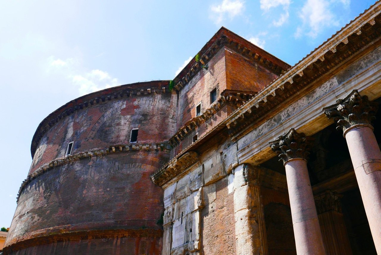
Pantheon Panoramic

Pantheon

Arch of Constantine

Quirinal Guardhouse

Chiesa del Gesù

Villa Borghese

Villa Borghese

Villa Borghese

Castel Sant’Angelo

Outside the Pantheon (Photo credits to Maia Zhang)

Capitoline Hill

Baths of Caracalla

Baths of Caracalla

Baths of Ostia Antica

Via Julia

Via Appia

Via Appia (With Mom & Dad)

Via Appia with Medieval Fortress

Via Appia

Trastevere

Art meets Industry

The Forum by Night

The Forum by Day

The Forum of Caesar

The World of Piranesi

Roman Water

Ostia Antica

Cat Sanctuary of the Piazza Argentina

Mussolini Meets Peroni

Roadside Monument to Motorcycle Death

Italian reads: “And the beast who does not gather…”

Saint Peter’s Basilica

Saint Peter’s Basilica


Cobblestones Commemorating Jews Deported to Auschwitz


SPQR


SPQR

Not Built to Last
This short film features Anchor Stone Blocks. They are a unique set of vintage, German-made, modular, stone building blocks from the late nineteenth century.
.