Envisioning Seneca Village

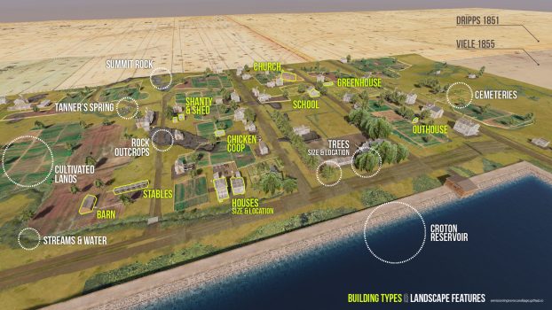
This collaborative project by Gergely Baics, Meredith Linn, Leah Meisterlin, and Myles Zhang. The project showcases a historically-accurate and archaeologically-informed 3D model of the historic African American community of Seneca Village, which was demolished in 1857 to build Central Park. The project combines digital reconstruction with extensive research, as public-facing tools to commemorate the village’s history and legacy. The project was recognized with multiple awards, widespread use in classrooms, and publicity by the Central Park Conservancy.

Visit: EnvisioningSenecaVillage.github.io VIEW PROJECT >

Setting Up Sex Offenders for Failure

This blind peer reviewed article discusses how stringent laws for sex offenders, like Megan’s Law and residency restrictions on where sex offenders may live, inadvertently lead to higher rates of re-arrest and re-conviction. These web of laws ironically increase the crime rate and cause thousands of low-income sex offenders to be re-arrested for crimes unrelated to the abuse of minors. Focusing on New York City, this research highlights issues with the home address requirement and suggests reforms to enhance public safety more effectively than current regulations.
Read in: Agora Journal of Urban Planning and Design VIEW PROJECT >

Mapping Manhattan Chinatown’s Public Realm

Pedestrian Observations explores Manhattan’s Chinatown’s public and private spaces through a detailed panoramic drawing and map of contested land uses. This project was co-published by Myles Zhang with non-profit artist collective City as Living Lab and architect Stephen Fan. The printed folding map highlights the vibrant interactions among diverse community members, while emphasizing the need for better public space management. Inspired by urban theorists, the project seeks to foster conversation about economic development and resilient urban environments.

《行人观察》(Pedestrian Observations) 将详尽的全景绘画对照各种土地利用的地图,深入探讨曼哈顿华埠的公共与私人空间的使用。该项目由张之远 (Myles Zhang),建筑师樊一鸣 (Stephen Fan), 和艺术家公益团体“城市实践工作室” (City as Living Lab) 联合出版。这份折叠地图描绘多元社区成员之间充满活力的互动,同时强调加强公共空间管理的必要性。本项目综合城市理论家的研究,提倡灵活变通的都市环境,从而促进经济发展。
Visit: CityasLivingLab.org/chinatown VIEW PROJECT >

Time-lapse Animation of Triangle Shirtwaist Factory Fire

Based on court transcripts, eye witness testimonies, primary sources, and historical maps, this animation reconstructs the workplace conditions and abuses that caused the Triangle Shirtwaist Factory fire. This fire on 25 March 1911, killed 146 garment workers and represents a turning-point moment in the history of organized labor in America. This project is the first – and only – accurate-to-the-inch virtual reality model of the entire factory floor. VIEW PROJECT >

Does the American city need a new “public entrepreneur” like Robert Moses?

The play “Straight Line Crazy,” performed in 2022 at The Shed in Midtown Manhattan, explores Robert Moses’s complex legacy as New York City’s mid-century urban planner. While he is celebrated for expansive public works projects, he is also criticized for displacing communities and ignoring dissenting voices. In this narrative, I reflect on city planning, government’s role in society, and the neoliberal shift of privatizing public goods. Who controls public space? Are today’s market forces as destructive to communities as Robert Moses’s “slum” clearance projects? VIEW PROJECT >

The Time Columbia Built an Artificial Moon in Low Library

The best definition of a university is, to my mind, a city from which the universe can be surveyed. It is the universe compressed into a city the size of Morningside Heights. Low Library, built in the 1890s at Columbia University, symbolizes the ambition to encompass knowledge in a single space, merging classical aesthetics with technological advancements. While the library served as a center of learning, its eventual obsolescence and partial abandonment reflects Columbia’s own evolution as an institution now more embracing of different viewpoints.

Read essay published in Columbia College today alumni magazine. VIEW PROJECT >

Architecture of Endurance in Manhattan Chinatown

The text and images for this walking tour were created for the non-profit artist collective City as Living Lab, as part of the Jane’s Walks tour series at the Municipal Art Society of NY. In this walking tour with observations of Chinatown’s history and streetscape, I feature a few of my watercolors. I guide visitors to see Chinatown’s architecture as a container and mirror of shifting social norms and a culturally rich immigration history. As people shape their built environment, their built environment in turn shapes them – their values, beliefs, health, and life outcomes.
Read transcript of tour and interactive map of Chinatown created for Municipal Art Society. VIEW PROJECT >

The Privatization of Public Space in Lower Manhattan

The decline of public spaces in Lower Manhattan is a pressing issue, threatening democracy and the sense of civic identity. While approximately 60% of Lower Manhattan’s ground area is technically dedicated to public use, only 25% remains truly accessible to pedestrians. Factors like cars, corporations, and surveillance have restricted urban life. Continued privatization erodes the quality and frequency of community interactions that are essential for democratic engagement and tolerance. VIEW PROJECT >

Street Grid Development vs. Population Density

This animation illustrates Manhattan’s urban development from 1801 to 2011, highlighting changes in street grid and population density. While Manhattan peaked at over 2.3 million residents in 1900, it had only 1.6 million in 2020. Improved public transportation after 1900 empowered hundreds of thousands of people to relocate from Manhattan to outer boroughs and suburbs that had more room and better quality housing supply. Manhattan today appears more visually dense and ever more populated with skyscrapers. But, ironically, about 40 percent fewer people live in Manahttan today than a century ago. Fewer people are living in larger apartments. This produces a net decline in population, even while there is a continuous growth in building sizes and heights. VIEW PROJECT >

Book Review of “Saving America’s Cities”

A review of Lizabeth Cohen’s book

“Saving America’s Cities: Ed Logue and the Struggle to Renew Urban America in the Suburban Age.” (New York: Farrar, Straus and Giroux, 2019. 547 pp.)

Winner of the Bancroft Prize in 2020 for the quality of her historical writing VIEW PROJECT >

The time-lapse history of Manhattan in two minutes

This two-minute time-lapse film illustrates the 400-year transformation of Lower Manhattan from a Dutch village to a modern metropolis, highlighting the impact of new technologies on evolving methods of urban representation. The film draws from seventeenth-century drawings to modern photography, showcasing how each generation perceived and depicted through art the city’s growth and the changing world around them. VIEW PROJECT >

Demolishing Public Space at New York Penn Station

The untimely and short-sighted demolition of old Penn Station in 1963 symbolizes the eroding quality of public space in New York City. In the conflict between developers and community voices in New York, the narrow considerations of economic profit triumphed over the broader community’s demands for historical preservation and high-quality public space. In this essay written for historian Evander Price’s summer 2020 class I took at Harvard University, I reflect on what the loss of this landmark reflects about the destructive nature of American capitalism. VIEW PROJECT >

Excavating Old New York Penn Station

In this computer model and series of image comparisons of past and present, I walk viewers through New York Penn Station. I identify the current and contemporary camera angles from which historical photos were taken in 1911.

The accompanying historical essay explores the historical significance and transformation of this trains station. Originally a grand architectural masterpiece from 1910 that embodied neoclassical design and values, the station was demolished in the 1960s, in order to build a modern structure that lacks its predecessor’s grandeur. VIEW PROJECT >

All New York City in one drawing

The ink on paper detailed panorama of New York City took 800 hours to complete. The image measures 45 inches high by 79 inches wide (114 cm by 201 cm) and features every neighborhood and key landmark the length of Manhattan island. As my art project created during the pandemic, it serves as a personal keepsake and reflection of my rich memories of New York City.

Drawing is shared online in lower resolution. Email me for the full-size file. Custom size prints will be mailed to your home address on request. VIEW PROJECT >

New York City Water Supply: animated history

This film uses time-lapse cartography from the 19th-century to the present to highlight the city’s ongoing struggle for clean water amidst growing urban challenges. New York City supplies unfiltered drinking water to nine million people, sourcing it from 2,000 square miles in Upstate New York through extensive aqueducts. This vital infrastructure, while integral to the city, remains largely unnoticed and buried just beneath our feet. VIEW PROJECT >

New York City in a Box

Inspired by the Stettheimer Dollhouse at the Museum of the City of New York, I created this pop-up model of New York City in a box. Measuring 8.0 by 15.5 by 2.5 inches (20 by 40 by 6 cm), this paper craft model showcases 30 hand-cut paper and tin buildings. A hand-cranked mechanism moves magnetized trains and airplanes through a hand-painted and imaginary landscape of New York City streets and neighborhoods. VIEW PROJECT >

New York: subway city of immigrants

As northbound Broadway dips down to the valley of 125th Street, the subway soars over the street. The subway viaduct is a jumble of steel slicing through the orthogonal city grid. The 125th Street viaduct is a massive arch, 250 feet from end to end, two hundred tons of mass channeled into four concrete pylons, resting on the solid bedrock of Manhattan schist. The subway is the intersection, where the underground and aboveground worlds of New York City converge. VIEW PROJECT >

Manufacturing the Picturesque at Central Park

Central Park, designed by Frederick Law Olmsted and Calvert Vaux in the 1850s, represents the tension between natural and manmade landscapes. Intended to offer an escape from urban life, its construction required extensive engineering and planning while masking the degree to which its landscape was artificial. The park’s design reflects real estate interests, infrastructure needs, and the divisions of social class in 19th-century New York. VIEW PROJECT >

Here Grows New York City

Here Grows New York is an American urban planning film directed by Myles Zhang and advised by urban historians Kenneth T. Jackson and Gergely Baics. The data visualization uses time-lapse cartography to follow the history of New York City’s infrastructure and street system development from 1609 to the present day. The video quickly went viral, gaining over five million views. The film is used in dozens of architecture and urban planning classes about the history of the urban form. VIEW PROJECT >

Architecture of Exclusion in Manhattan Chinatown

This essay discusses the historical and contemporary challenges faced by the Chinese community in Manhattan’s Chinatown, highlighting the impact of the 1882 Chinese Exclusion Act and ongoing discrimination against immigrants and working-class communities. Despite systemic barriers, the community shows resilience and maintains cultural identity amidst gentrification and urban development. VIEW PROJECT >

Railroad commuting patterns in New Jersey

NJ Transit carries over 90,000 commuters per day to and from New York Penn Station, the busiest rail station in the Western Hemisphere. Like spokes on a wheel, these commuter rail lines radiate from the urban core of Midtown Manhattan. Hover over stations to view statistics. Dot size corresponds to number of riders per day: Large dots for busy stations and small dots for less busy stations. VIEW PROJECT >

Geography of Marijuana Arrests

Before the legalization of recreational marijuana in 2021, the NYPD reported over 102,000 marijuana-related arrests in 2017, disproportionately affecting Black males from low-income areas, despite similar usage rates among other demographics. This system wastes taxpayer dollars and perpetuates a cycle of criminalization for those impacted by arrests. In this series of data visualizations and maps, I walk readers through the geography of marijuana incarceration. VIEW PROJECT >

New York City Subway Ridership Patterns

The MTA’s 424 subway stations and 665 miles of track are analogous to the human circulatory system. Every weekday pre-coronavirus, the subway carried 5.4 million people, mostly commuters. This daily commute is ordered, structured, and rhythmic – as Manhattan’s population swells during the daily commute and then contracts by night. Each passenger symbolizes the movement of a single red blood cell. With each paycheck, the oxygen of capitalism flows from the heart of Manhattan to the cellular homes in the outer boroughs. VIEW PROJECT >

Where in the world is modernism?

What if the nationality of every artist represented in the Museum of Modern Art’s collections were mapped to illustrate the museum’s evolving geographic diversity from the 1920s to today? Watch this data visualization that shows the provenance and geographical origins of 121,823 works of art selected from MoMA’s collections. Explore supporting data visualizations and interactive dashboards. VIEW PROJECT >

A History of Historic Preservation in New York City

Developed with historian Kenneth Jackson.

Data analysis of NYC landmarks since 1965 reveals trends and biases in the landmarks preservation movement. By 2018 estimates, New York City has granted historic
landmark status to 128,594 structures across Five Boroughs. This visualization and the accompanying analysis assess the geographical spread, location, and age of landmarks with publicly-available metadata. VIEW PROJECT >

A Brief History of Mulberry Bend

Mulberry Bend, nestled between the New York County Criminal Court and the tenements of Chinatown, is at the geographic crossroads of urban history. At 500 feet long and 50 feet wide, Mulberry Bend is named after the slight turn the street makes midblock. The Bend has a rich, 350 year history: marsh, city slum, site of urban renewal, and now heart of the Western Hemisphere’s largest Chinese enclave VIEW PROJECT >

The Geography of Art History

According to the Metropolitan Museum of Art Related: Data analysis and visualization of 120,000 works in the Museum of Modern Art In this film, each colored dot indicates one location represented by art in the Met’s online database. Dot location indicates artwork provenance. Dot size indicates the number of objects from this place. The time each dot appears corresponds to the year this work was created. This data is assumed to be an accurate sample size. Over the past few years, the Metropolitan Museum has catalogued over 25% of its holdings online. This represents ~590,000 objects, covering over 5,000 years… VIEW PROJECT >

Columbia University Artwork

This digital portfolio highlights various artistic projects, time-lapse drawings, and models I created of Columbia University’s campus, during the time I was a student there. The portfolio features a detailed ink and watercolor campus drawing, a mini model of the campus made from paper, and six time-lapse sequences documenting artistic processes. Featured in multiple publications, these creations are now a personal souvenir of my education at Columbia.

Contact me to download source files or to order custom prints mailed to your home address. VIEW PROJECT >

New York Chinatown: time-lapse drawing

This time-lapse of Manhattan Chinatown took sixty hours to complete and measures 26 by 40 inches. The artwork features Chinatown’s tenements in the foreground, with Lower Manhattan’s skyscrapers towering above.

Drawing is shared online in lower resolution. Email me for the full-size file. Custom size prints will be mailed to your home address on request. VIEW PROJECT >

Model of Jane’s Carousel in Brooklyn

A wind-up music box featuring Jane’s Carousel along the Brooklyn Waterfront. When closed, the antique cigar box measures a mere 7 by 7 inches and 3 inches deep (18 x 18 x 8 cm). When opened, the Brooklyn Bridge and historic Jane’s Carousel fold out. The carousel spins to the tune of the music while the moon slides across the night sky. VIEW PROJECT >