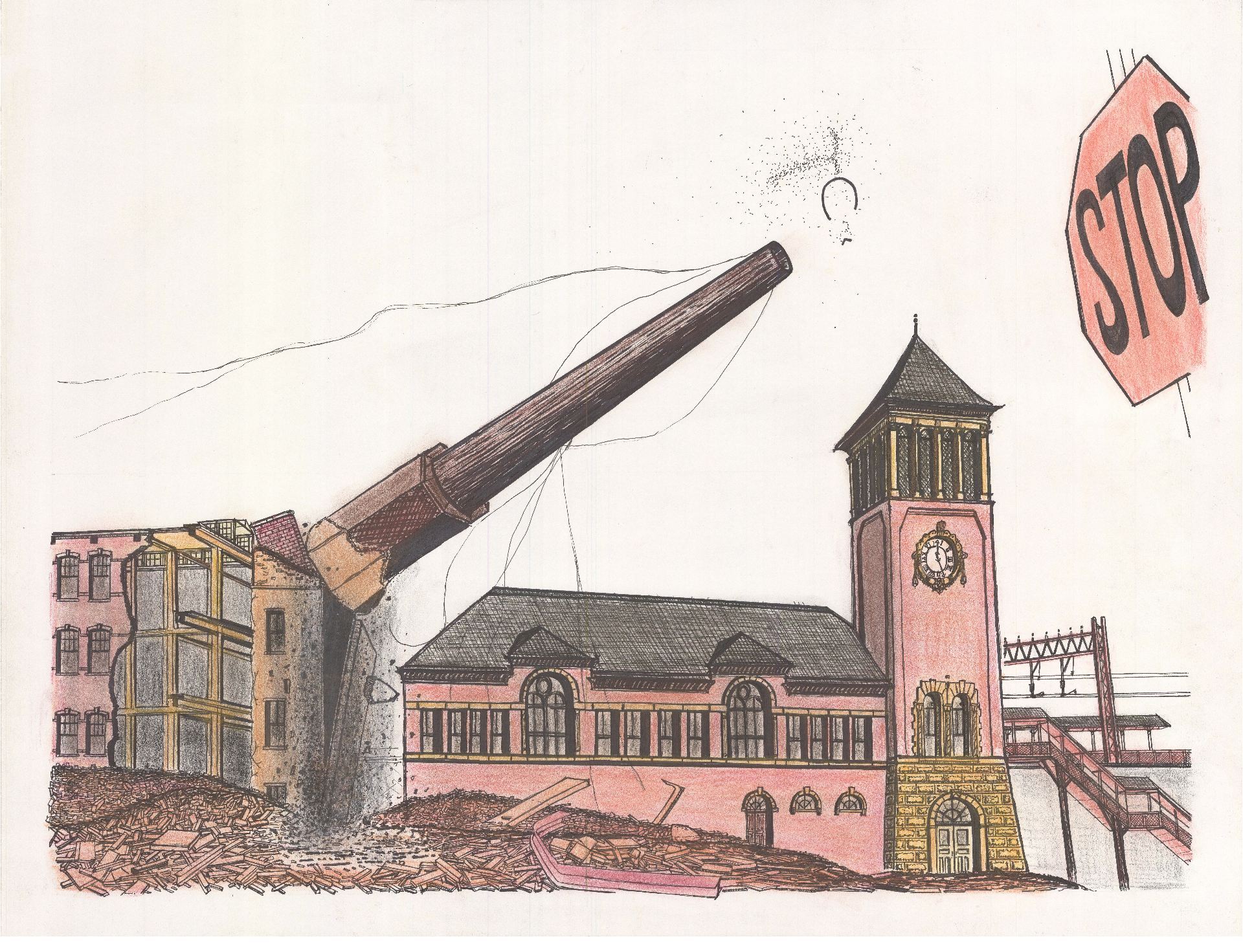
Warren Street School Demolition

As featured in:
1. Darren Tobia for Jersey Digs

2. The Vector, NJIT’s student newspaper
3. Read my analysis of campus architecture for some context on this demolition.

.

.

“Those historians want to keep these old bricks. I can’t see why you’d want that s**t. F**k it. We might just slip in some new bricks. You can’t tell the difference anyway.”

– Conversation overheard between demolition workers at the Warren Street School

.

.

.

“The university has never demolished any historic building of any value. Name one.”

– President of the university during a community meeting in October 2020

.

When walking past the historic Warren Street School in spring 2021, a demolition scene by the local university shocked me. The building had been nominated to the National Register of Historic Places, together with five other Newark school buildings. Therefore, the drastic destruction should have been under state and local reviews. But demolition was approved on April 1, 2021, on April Fools Day.
The 150-year-old school was built by Jeremiah O’Rourke, the Supervising Architect for the U.S. Treasury Department and the architect of Sacred Heart Basilica and some of the largest civic structures in 1890s America. Before the university acquired the building in salvageable condition, it was the home of American History High School, founded by beloved Professor Clement Price to promote learning of American and local history by coming generations. Even with its windows now stripped out and demolition equipment parked around it, the grand master work for Newark’s proud history of public education was crying for this painful end delivered by the wanton and shameful act of university leadership.
At the orders of the university president, a short-sighted acceleration of demolition around the campus in the country’s third oldest major city has been savagely damaging the city’s history. These actions add to the list of hundreds of buildings already demolished in the area. While institutions like Rutgers and developers like RBH and the Hanini Group have embraced historic preservation, this university still insists on wiping the slate clean of history that it views not as an asset but as an inconvenience.

.

.

The future of any great institution depends on the preservation and appreciation of its own history. I believe in saving old buildings not just because they are pretty. More than an argument for historic preservation on aesthetics alone, history – and the visible presence of history – shapes our appreciation for the sacrifices of those before us. Passing by the Warren Street School for twenty years, I thought every time of the thousands of immigrant children who attended school here for over 170 years uninterrupted. I thought of the Irish and Italian brick masons who carved the school’s terracotta ornaments by hand on wages of 5 and 10 dollars a day. I thought of these children’s parents, who came to Newark by steamship and steam engine to give to their children a better shot at life than they could ever dream of. I thought of the architect who built this building in the 1880s with care and love and hope that better civic architecture will produce better citizens.
It is the burden of history that shapes us, and it is on our commitment (or failure) to interpret and enrich history for the next generation on which each of us will be judged. I am reminded of architectural critic Ada Louise Huxtable’s words in 1963 when she described with horror the demolition of New York Penn Station.
“Until the first blow fell no one was convinced that Penn Station really would be demolished or that New York would permit this monumental act of vandalism against one of the largest and finest landmarks of its age of Roman elegance. Somehow someone would surely find a way to prevent it at the last minute – not-so little Nell rescued by the hero – even while the promoters displayed the flashy renderings of the new sports arena and somewhat less than imperial commercial buildings to take its place.
“It’s not easy to knock down nine acres of travertine and granite, 84 Doric columns, a vaulted concourse of extravagant, weighty grandeur, classical splendor modeled after royal Roman baths, rich detail in solid stone, architectural quality in precious materials that set the stamp of excellence on a city. But it can be done. It can be done if the motivation is great enough, and it has been demonstrated that the profit motivation in this instance was great enough.
“Monumental problems almost as big as the building itself stood in the way of preservation; but it is the shame of New York, of its financial and cultural communities, its politicians, philanthropists, and planners, and of the public as well, that no serious effort was made. A rich and powerful city, noted for its resources of brains, imagination and money, could not rise to the occasion. The final indictment is of the values of our society.
“Any city gets what it admires, will pay for, and, ultimately, deserves. Even when we had Penn Station, we couldn’t afford to keep it clean. We want and deserve tin-can architecture in a tin-horn culture. And we will probably be judged not by the monuments we build but by those we have destroyed.”

.

.

.

.


.

.

Learn from the past.
Live in the present.
Plan for the future.

This was the inscription mounted at the Warren Street School’s entrance, which demolition cranes tore off and crushed in the dumpster. A site that once had a past, now has no past to learn from and to inform the present and future. Through demolition, our link with history is severed.

Bulldozer Urbanism

As featured in:

1. Preservation New Jersey: Ten Most Endangered Historic Places  May 18, 2021
2. After Warren Street School Demolished, James Street Named ‘Most Endangered’  May 18
3. Newark Historic District Designated as Endangered  May 18, 2021
4. James Street Community Rushes to Stall NJIT’s Demolition of Historic School  May 6, 2021
5. Nothing Lasts Forever, Not even at NJIT   February 1, 2021
6. SHPO Delays NJIT’s Plan to Raze 4 Historic Buildings    January 8, 2021
7. NJIT’s Plans to Demolish Buildings in Historic District Temporarily Derailed   January 7, 2021
8. Old Jail Could Inspire Youth to Stay Out of Prison – But Only If It Survives   July 4, 2020
9. NJIT’s Plans to Modernize Its Campus Could Cost Newark Some History   March 12, 2020

.

James Street Commons demolitions completed and proposed as of April 2021

.

Note: Visiting NJIT’s architecture school at age six and seeing students working there was what initially inspired my desire to study architecture. NJIT is an asset to Newark, and the school deserves the quality of campus architecture to match. I wrote and circulated this essay about NJIT’s under-performing campus design to members of NJIT and the Newark community. I am sharing it online, too, in the hope that future leaders of NJIT will collaborate with the community to create campus architecture that is culturally and historically sensitive to Newark.

.

A Pedestrian’s Observations

Experiencing NJIT’s campus from the street

In publicity materials and in meetings with Newark residents and historians, the New Jersey Institute of Technology emphasizes the quality of its campus architecture and its track record of historic preservation. The school highlights its Central King Building (formerly Central High School) and Eberhardt Hall (formerly Newark Orphan Asylum) as trophies of historic preservation.
However, beyond its fortified campus carved out during the 1960s era of “urban renewal,” the university is now escalating its demolitions in the neighboring James Street Commons Historic District. Listed since 1978 on the National Register of Historic Places, this neighborhood is the city’s first historic district and contains some of Newark’s most significant historic assets. The spending of millions of dollars on building demolitions is odd when NJIT faced a 35 million dollar budget deficit in the first half of 2021,[1] and when other Newark institutions and developers are following an opposite path of historic preservation.
As NJIT expands into the James Street Commons Historic District, there is concern that new construction will not improve the built environment. For instance, NJIT’s proposal for 240 MLK included few to no windows at pedestrian eye level. The entrance to the parking garage and trash collection was from the side of the building that faced toward the residential neighborhood. Several other structures in the neighborhood are also at risk or have already been demolished by NJIT, such as Mueller’s Florist, which was a former corset and tin toy factory built in the 1880s to 1890s. Similarly, NJIT acquired the c.1890 brownstone at 317 MLK for ~$450,000 in livable condition. In following weeks and months before NJIT received demolition approvals, windows were left open and removed, thereby accelerating decay and water damage. The current demolitions follow a longer pattern among hundreds of other buildings demolished in my neighborhood. This would all be okay if only there was better quality architecture to replace what is being lost.
I write this essay as a series of architecture observations followed by recommendations. Firstly, I provide examples of how NJIT’s current campus design is detrimental to neighborhood street life. Secondly, I document the neighborhood’s appearance before and after NJIT’s interventions through my photo comparisons of past and present. Thirdly, I provide examples of more sensitive models for alternative neighborhood redevelopment.

.

Completed in 2017, NJIT’s athletic facility is the newest building on campus.
The pedestrian view along the sidewalk has no windows.

.

Demolition of the 140-year-old Bowers corset factory in progress (aka Mueller’s)

.

Map of NJIT campus. Buildings that face toward the street with no windows at or near eye level are indicated with red lines. Surface parking lots and parking structures for commuter students and faculty are indicated with red squares.

.

1. Architecture of Fear at NJIT

NJIT’s newest architecture does not actively promote urban street life. For instance, Fenster Hall opened in 2004 at a cost of 83.5 million dollars. The architect Charles Gwathmey told the audience at the building’s dedication: “University buildings…have an obligation to give the campus a sense of place, and happily, that is what we are achieving here.” The main entrance to Fenster Hall faces inward to the campus community. Meanwhile, the side that faces toward the neighborhood and city is the parking garage and eight stories of bare concrete that rise straight up with no windows at ground level.

.

.

The photo above is the side of Fenster Hall that faces toward the neighborhood. The emergency police call box and video surveillance signs might make out-of-town car commuters feel safe. But defensive architecture perversely has the opposite effect of making local residents, who must live with this architecture, feel excluded and surveilled.
Activist and urbanist Jane Jacobs wrote that attractive and safe neighborhoods to live in will always have “eyes on the street.” In her ideal neighborhood, shop windows, apartments, and urban life always face to the street. In active and mixed-use neighborhoods where people both live and work, there is always 24-hour street life and therefore people looking from their windows onto the street at all times.
The blank walls and surveillance cameras surrounding NJIT’s campus can be justified on grounds of public safety. However, hostile architecture that turns away from the city eliminates eyes on the street and, ironically, encourages the kind of crime it was built to defend against. In successful campus architecture, there will be reduced need for surveillance cameras.

.

The side of Fenster Hall that faces toward the city discourages street life and looks like a fortress. There once was a brick mansion here like the Ballantine House or Krueger-Scott Mansion.

.

Metropolitan Correctional Center in Brooklyn
Google Earth street view image

NJIT Department of Mechanical and Industrial Engineering

.

Sidewalk view of NJIT Microelectronics Center

.

Warren Street School: NJIT says the building is too fire damaged to save.
The photo above shows the building after the fire.

.


Warren Street School before


and during NJIT’s demolition

.


Warren Street School before


and during NJIT’s demolition

.

Another project is the demolition of the Warren Street School for NJIT student dorms. NJIT announced demolition plans in fall 2020 on its website. The Warren Street School from the nineteenth-century is by Jeremiah O’Rourke, a resident of Newark and the same architect as Sacred Heart Basilica and some of the most important civic structures in the US. The Warren Street School passed preliminary review to be included on the National Register of Historic Places. It is also be included in Preservation NJ’s 2021 list of the ten most endangered historic sites in the state.
As a final image, here is a photo past and present of NJIT’s architecture school. At left is the Victorian structure named Weston Hall, built c.1886 as NJIT’s first home. At right is the architecture school that now occupies this site. Originally, Weston Hall faced toward the street and city. Now, the current building at this site faces away from the city and presents its rear toward the public street.

.

One of NJIT’s first homes at Weston Hall[2]

was demolished and now looks like this.

When NJIT’s architecture school hosted a Regional Plan Association conference in 2004, the organizers were afraid that Mayor Cory Booker and attendees could confuse the permanently locked street doors for the building entrance, shown above at right. A note was left on the door: “Mr. Mayor, please enter through the door inside the campus.”

.

2. The campus of NJIT before and after urban renewal

When the Historic Sites Council was reviewing recent demolition applications for old buildings in the James Street Commons Historic District, one of the commissioners asked: “If NJIT is taking something away from the community, what is it giving back?” This is a more fundamental question that goes beyond historic preservation. All buildings have a lifespan, and preservation is not always possible. But if a building is demolished, the building that replaces it needs to be higher quality and more actively contribute to the quality of street life than what was there before.
NJIT is a commuter school, and most educators who work at NJIT live outside Newark. This is unfortunate because Newark would benefit from having NJIT more involved in the local community. In some ways, NJIT community members who choose to live outside of Newark cannot be faulted because many Newark neighborhoods are not aesthetically pleasing. Therefore, it is in the school’s own interest to make the surrounding neighborhood a more pleasant place to live, walk, and work.
Unfortunately, the photo comparisons below illustrate that the walkability and aesthetics of my neighborhood have deteriorated since the 1960s. Universities are drivers of upward social mobility, economic growth, and knowledge production. NJIT deserves credit for this. However, the university’s built environment falls short of expressing progressive values. Architecture that presents a blank wall to the street does not benefit the city aesthetically. More crucially, this does not benefit the students’ educational experience either. Architecture that turns away from the city communicates to students that the urban environment is not safe and not worth engaging in.
In 1962, after over ten years’ preparation, the Urban Renewal Project NJ R-45 (Newark College Expansion), with federal capital grants of $7,674,309 and millions more of state and local bonds, displaced more than 1,300 families. Through eminent domain, the state demolished 87.5 acres of brownstones and historic structures next to the now James Street Commons Historic District. Five years later, the government expanded the urban renewal projects and displaced thousands more people for the campus of UMDNJ. The resulting civil unrest of July 1967 injured 727 people and killed 26. Newark’s reputation still suffers from the legacy of urban renewal.
These photos were all taken in 1960 immediately before the neighborhood’s demolition for NJIT. The wholesale demolition of old buildings, while unfortunate, was an opportunity to build back better. This opportunity was squandered with defensive architecture. Moving forward, NJIT must take every opportunity to shift toward a more inclusive and street-facing campus.

.

Mueller’s Florist in 1960[3]

Building demolition in 2021

.

Intersection of Warren and Summit Street in 1960[4]

The site is now a parking lot and building with no street-facing windows at eye level

.

Warren looking west to High Street in 1960[5]

The same scene today. The university bookstore here has no windows to the street.

.

Summit Street above Raymond Boulevard in 1960, home of a paper box company[6]

Now a multi-story parking garage for commuter students and faculty

.

251 to 245 MLK in 1964[7]

Now a parking lot for St. Michael’s and NJIT

.

Summit Street and New Street in 1960[8]

The winch used to lift up bales of hay is visible in the upper left of carriage house.

Fenster Hall now stands here.

.

Intersection of Bleeker and Hoyt Street in 1960[9]

Department of Mechanical and Industrial Engineering

.

3. A sensitive development model by Rutgers Newark

Rutgers made urban renewal mistakes in the past. But with a new university administration, the school is learning from past mistakes and becoming a better citizen of Newark.

.

Rutgers Living-Learning Community (Image courtesy of RBH Group)

.

Completed just last year is Rutgers’ Living-Learning Community on the full block just next door to the Hahne’s Building. At this site within the same James Street Commons Historic District as NJIT’s continuing demolitions, Rutgers inserted new student housing as infill within the urban environment. Existing structures at three of the four corners of the site help to mask the scale and mass of the new construction. The building is not too tall, includes ground floor stores, and employs brick materials and floor heights that mirror the neighboring brownstones and businesses from the nineteenth century. The result is a project of high quality that not only responds to its environment but actually feels safer and more pleasant to walk past.

.

Teachers Village (Image courtesy of RBH Group)

.

Similarly, the Newark Teachers Village by Newark-born Richard Meier looks toward the street and stimulates street life with ground floor activities. The project is a first in Newark because it is targeted at encouraging educators to live in the community where they work. The developer was selective about preserving some old buildings to create a more visually rich and organic streetscape of old and new. The average building is no higher than four to five stories and includes frequent setbacks and varieties of materials. Although construction of the NJIT campus displaced an entire neighborhood, there is the opportunity for new construction to resemble the quality of urban life that was lost.

.

Urban renewal done wrong:
NJIT’s Cullimore Hall on Bleeker StreetMost of the façade has no windows and detracts from the quality of street life.Those boxes at sidewalk level are mechanical equipment.
Urban renewal done right: Rutgers’ Bleeker St. brownstones just one block from Cullimore Hall.These are a few of the brownstones that Rutgers fixed up and turned into university offices. The building entrances all face toward the city. Rutgers put a flowerpot at sidewalk level.

.

Urban renewal done wrong:
Warren Street SchoolThis school was built in the 1890s by Jeremiah O’Rourke. NJIT demolished this landmark.
Urban renewal done right:
Old St. Michael’s HospitalThis hospital was built in the 1880s by the same Jeremiah O’Rourke. The Hanini Group is renovating this building.

.

Old St. Michael’s Hospital and Warren Street School are two vacant and landmarked buildings by the same architect, built with the same method of brick construction, in the same neighborhood, and at the same period of time. However, one of these buildings is being demolished by NJIT while the other is being saved. The Hanini Group is transforming St. Michael’s Hospital into apartments and an arts center. Adaptive reuse of the hospital might be more expensive than demolition, but the success of a project must not be assessed on profit alone. As a non-profit and educational institution, NJIT needs to think longer term about higher quality projects that might have lower profit margins.

.

Urban renewal done wrong:
NJIT Fenster HallParking garage at Fenster Hall: The rock landscaping in the foreground and the bare concrete wall are unpleasant to walk past.
Urban renewal done right:
Rutgers Living-Learning CommunityRutgers’ new parking garage: There are street trees, brick walls, and shop windows at ground level.
What sets NJIT’s Fenster Hall and Rutgers’ Living-Learning Community apart is the attitude of the institution to the Newark community. Fenster Hall turns its back to Newark and expresses fears of urban life. Rutgers’ newest projects are part of the city and neighborhood at a later time when Rutgers reassessed its responsibility as an urban citizen. Infill housing and historic preservation put “creative restraints” on developers and institutions. When developers like Rutgers incorporate history into their projects, the process, approvals, and financial cost might be more difficult, but the project is universally of higher quality.
The priorities and values of an institution are reflected in the architecture it creates for itself. NJIT should be an asset to Newark’s economy with so many faculty and staff who genuinely care about Newark. The school deserves better architecture that reflects its commitment to Newark. NJIT and developers alike need to think about historic preservation and the pedestrian scale in all future projects.
“Transformation is the opportunity of doing more and better with what is already existing. The demolishing is a decision of easiness and short term. It is a waste of many things—a waste of energy, a waste of material, and a waste of history. Moreover, it has a very negative social impact. For us, it is an act of violence.”
– Anne Lacaton recipient of the 2021 Pritzker Architecture Prize

.

Endnotes and Image Credits

[1] https://www.njit.edu/pandemicrecovery/njit-fiscal-update

[2] https://newarkchangingsite.wordpress.com/ Images scanned from the collections of the Newark Public Library

[3] All historic images are from the Newark Public Library’s collection of photos by Samuel Berg: https://digital.npl.org/islandora/object/berg%3A96b40a0d-640a-46c0-bf48-8a232b155ccb

[4] https://digital.npl.org/islandora/object/berg%3Ab1889dcf-5009-4e8b-bbec-588c63fe3e9a

[5] https://digital.npl.org/islandora/object/berg%3Ae3100c3e-2ac2-4fb2-b42a-987ffbc0f781

[6] https://digital.npl.org/islandora/object/berg%3Ad65f7167-96a8-4e45-bb72-594ec57bf295

[7] https://digital.npl.org/islandora/object/berg%3Af94bf759-2be2-45dd-8e88-e3dd43ca8296

[8] https://digital.npl.org/islandora/object/berg%3Af58b08d8-f527-49d3-b841-2176bbba54d1

[9] https://digital.npl.org/islandora/object/berg%3A0286e6d3-b8ac-46b7-8968-5e8a39f863e2

Architecture of Endurance in Manhattan Chinatown

As featured by City as Living Laboratory
And the Municipal Art Society of NY

.

Eldridge Street Synagogue and Manhattan Bridge

.

Welcome to Chinatown. With a population of ~150,000, this neighborhood is the largest ethnic Chinese community in the Western Hemisphere. Join us on a mile-long walk through space and time.
A few questions to keep in mind during our walk:
+ How has Chinatown changed over two centuries of urban growth? What has not changed?
+ What other cultures and ethnicities lived here before or simultaneously with the Chinese?
+ How are the challenges the Chinese faced imprinted on the built environment of Chinatown?
+ How does Chinatown street life blur the boundary between public and private space?

.

Interactive Tour Map

.

.

Thank you to Liza Cucco, Olivia Georgia, and Stephen Fan for co-creating this virtual tour. City as Living Laboratory has been exploring this neighborhood through walks for many years. A recent initiative explored issues of climate, equity, and health in Chinatown’s unique food system.

.

Tour Stops

.

Route of walking tour superimposed over 1782 map of Manhattan

.

1. Bowery & Canal Street

Start at the southwest corner of Canal Street and Bowery, opposite the entrance to the Manhattan Bridge. The Bowery was a former Lenape trail turned dirt road linking Lower Manhattan to farms just north of where you are standing. Bowery comes from the word bouwerij in Dutch, or bower in English, meaning “a pleasant shady place under trees or climbing plants in a garden or wood.” Ironically, Lower Manhattan now has less green space per resident than most other parts of New York City.
Walk south on Bowery to our next stop at Pell Street.

.

2. Edward Mooney House

Edward Mooney House (top) and Church of the Transfiguration (bottom)

The four-story home built in 1785-89 has a sloped roof and ornamental details in the Federalist style that was popular around the time of the American Revolution. Edward Mooney, a wealthy butcher, built his house at the northern edge of Manhattan’s urban growth and within site of farms and rolling hills. It is the only surviving town house in Manhattan from the period of the American Revolution, and it is a reminder of past generations and land uses in Chinatown.
In 1790, New York City was capital of the United States and consisted only of Manhattan. The town had a population of 33,000, in contrast to 2.3 million in 1910. Chinatown and the Lower East Side ranked in 1910 as one of the densest places on earth with over 300,000 people per square mile. Manhattan’s population has fallen to 1.6 million, but imagine the streets three times as crowded.
With nineteenth-century revolutions in Germany, famines in Ireland, poverty in Italy, and organized massacres of Jews in Eastern Europe (called pogroms in Yiddish), immigrants arrived by the millions; Manhattan’s population swelled. The Chinese began arriving by ship in the 1820s and 1830s. By the 1850s, there were about 150 Chinese sailors in Lower Manhattan – most migrants hoping to make their fortune in America and then return home. Most Chinese immigrants to America spoke Cantonese due to the relative poverty of this region of China. Fleeing from the poverty of China to the promise of California, they found work on the Transcontinental Railroad. Fleeing the white nationalists and death threats of California, they sought refuge in New York. Wealthy merchants in houses like Edward Mooney’s moved north, away from the pestilence and crowded conditions of Lower Manhattan. In a few decades, the area transformed from a neighborhood of English-style townhouses for the middle classes and wealthy into the mass of tenements you now see.

.

3. Heading to Doyers Street

Walk down Pell Street to the intersection with Doyers Street. Notice the multi-story vertical signs that hang from the tenements. They are similar to the neon signs that clutter the streets of Hong Kong. Also notice the profusion of almost a dozen barbershops. As each generation of immigrants arrived in Manhattan, they brought with them the aesthetics and traditions of their homeland that were then integrated into the island’s streetscapes.
As you walk down Doyers Street, notice the eccentric curve of the road. Before the 1811 Manhattan grid standardized urban growth, individual landowners decided how best to divide and resell farmland for development. With no standard plan, Lower Manhattan grew organically as a crazy quilt of intersecting streets.

.

Pell Street and Doyers Street

.

4. Abacus Federal Savings Bank

As you approach Bowery again, notice the Chinese jewelry store to your right, one of many in the area. As immigrants in America, the Chinese were locked out of the financial system, denied home mortgages, and often relied on jewelry to symbolize and preserve wealth. Turn left and walk forty feet back up Bowery. You will see the Abacus Federal Savings Bank, founded by Chinese immigrants. In a gesture to the preferences of its immigrant customers, Abacus offers thousands of safe deposit boxes in its basement for the storage of jewelry and other valuables. Abacus was the only bank prosecuted after the 2008 financial crisis, and was later cleared of all charges by the jury’s unanimous decision. Manhattan District Attorney Cyrus Vance Jr., who is investigating Donald Trump’s taxes, charged Abacus with falsifying loan applications so that borrowers would qualify for home mortgages.

.

Chinatown businesses

.

5. Kimlau memorial gate

Across the street, you will see the Kimlau memorial gate commemorating Chinese-Americans who served and died in the US military. Behind the gate is a statue of Lin Zexu, a nineteenth-century Chinese scholar and official who fought and failed to stop British and colonial powers from smuggling drugs into China in the name of “free trade” and getting millions of Chinese addicted to opium. Before 1965 reforms to US immigration policy, generations of Asians served in the US military while their friends and family were prohibited from immigrating, marrying, or owning their own homes in the suburbs. Historian Mae Ngai characterizes America’s relationship with the Chinese as simultaneously wanting cheap products and foreign labor without suffering the presence of the people who sacrificed and labored for them.

.

6. Church of the Transfiguration / Wing on Wo & Co.

Walk down Bowery until you reach the intersection with Mott Street. Turn right and walk one block up Mott Street to the Church of the Transfiguration. At this site since 1801, it was first an English Lutheran church, and for a brief period in the nineteenth century a largely Irish church with a Cuban pastor. Later still, it became an Italian congregation. As Chinese replaced Italians as the neighborhood’s dominant ethnic group, the congregation became Chinese. Catholic masses are held in English, Mandarin, and Cantonese.
Across the street, you will find Wing on Wo & Co., the oldest continually-run family business in Chinatown. Its fifth-generation owner, Mei Lum, also runs the W.O.W. project, a community-based initiative that reinvents, preserves, and encourages Chinatown’s creative culture and history through arts, culture, and activism. W.O.W. hosted one of CALL’s 2018 workshops with artist Jean Shin.
Continue downhill along Mosco Street.

.

Photos of Mulberry Bend by Jacob Riis

.

7. Mulberry Street

Notice the several funeral homes along this stretch of Mulberry. As indicated by the century-old Baroque entrance of the Wah Wing Sang Funeral Corp., many funeral homes in Chinatown used to belong to the Italians. Italian brass bands still accompany traditional Chinese funeral rites. Opposite Wah Wing Sang, notice the corner store selling “Hell Bank Notes,” paper dollhouses, and paper versions of luxury products that will be burned at funerals in the hope that the deceased will be wealthier in the next life than he or she was in this life.
The poorest and least-favored immigrants were concentrated in this area known as Five Points. Tenements here were among the most crowded in the city, water was delivered in wooden pipes, and sanitation was difficult due to the marshy soil, causing immigrants to suffer or die here in the thousands. The ~12,200 deaths in the cholera outbreaks of 1832, 1849, 1854, and 1866 were concentrated where you are standing. One Virginia doctor treating cholera victims in Five Points concluded that their living conditions were worse than those of the worst-treated slaves in the American South. The immigrants were, he wrote, like “a flock of sheep swept off suddenly by some distemper.” Charles Dickens, lifelong chronicler of the miseries of the English working class, compared Five Points and the future site of Chinatown as worse than the slums of his native England. In language that parallels the income inequalities that plague present-day New York, Dickens described the experience of seeing wealthy ladies in fancy dresses shopping on Broadway, while thousands were gripped by poverty around the corner. He described in 1842, with surprise and horror, the site of feral pigs roaming the streets, rag pickers, and the constant scent of fever and death.
“This is the place: these narrow ways, diverging to the right and left, and reeking everywhere with dirt and filth. Such lives as are led here, bear the same fruits here as elsewhere. The coarse and bloated faces at the doors, have counterparts at home, and all the wide world over.”

.

8. Columbus Park & Collect Pond

This neighborhood was once part of a wetland the city filled in, and the spot you are standing on was part of a small marshy body of water known as the Collect Pond.
Eric Sanderson tells us how this place came to be what in his seminal 2013 book Mannahatta:
“In the early days of the nineteenth century, city leaders allowed a tannery to set up shop on the edge of the Collect. Tanneries preserve the skins of animals by soaking their hides in plant chemicals (tannins – the same compounds that give a young red wine its bite) extracted from local trees, especially hemlock and oak, which, when disposed of as waste in the convenient nearby pond, rapidly poisoned the water, spoiling what had been the city’s best and most accessible drinking water. Remember that New York City was built on an island in a tidal (i.e., salty) estuary, with no possibility of drinking from the Hudson and East rivers. The spoilage of the Collect led to plans to bring in water from uptown, orders to dig wells to extract the groundwater downtown, and eventually construction of the Croton water system, which would bring water from Westchester, thirty miles away. (It also led to a bank – Aaron Burr formed the “Manhattan Water Company” in 1808 to bring water from streams uptown, but then used the assets to form a bank, later known as the Chase Manhattan Bank, and now a part of JPMorgan Chase.) In the meantime, city leaders voted to fill in the verdant Collect, by leveling the adjacent hills into the stagnant waters and declining marshes.
“The city advanced rapidly over the site with the construction of tenements, churches, and businesses around the short-lived and quickly forgotten “Paradise Square.” Within a decade the land began to subside, having been incompletely filled; the formerly luxuriant vegetation of the shrub-swamp and coastal-plain-pond shore, now trapped in the soil, began to decompose and release unpleasant vapors. In other words, the landscape, disturbed by the pond being filled, began to adjust, by stinking and collapsing. Those people who could left for more salubrious uptown addresses, while those who couldn’t, mainly immigrant Irish and freed blacks, stayed on in increasingly dangerous and crowded tenements that sank slowly into the mire. The neighborhood became known as Five Points, for the five streets that once met over the northern edge of the Collect Pond; some of its particular charms are recalled in Martin Scorsese’s movie Gangs of New York (2002). Charles Dickens visited, and in his American Notes (1842) deplored the slum neighborhood, with its unpaved alleys filled with knee-deep mud, free-roaming pigs, rotting and sinking houses, and children sleeping on the steps. Gangs established their own competitive balance; the Plug Uglies, Dead Rabbits, and Roach Guards marked out territory as the woodcock and osprey had once done. It wasn’t until Jacob Riis, the journal and reformer, began documenting the conditions in the 1880s with a new invention, the camera, that things began to change. The city bought up and condemned most of the tenements and replaced them with large civic buildings, including the reconstructed Tombs, the city prison, and the New York Courthouse. Now, when accused criminals are arraigned in the gray stone buildings of Foley Square, they face the judge on the shores of the old Collect Pond.”
Eric W. Sanderson and Markley Boyer. “The Old Collect.” In Mannahatta: a Natural History of New York City. Abrams Books, 2013, pp. 167-69.

.

9. New York County Criminal Court

The Art Deco limestone ziggurat of the New York County Criminal Court towers above the park. On a good day, the courthouse windows are left open. The smells of Chinese food and the sounds of Chinese opera drift inside, while everyone from the likes of Harvey Weinstein, to Occupy Wall Street protestors, to South Bronx teenagers charged with petty shoplifting are on trial. It is a strange coincidence that a Chinese community that has suffered from generations of state-sanctioned racism should itself be so physically close to the center of power, and yet so politically distant from making the decisions that effect their fate. Current proposals for a 50-story skyscraper of the new city jail will tower over Columbus Park and the neighborhood.
Walk to the intersection of Mulberry and Bayard Street at the end of the park, and head get back onto Mott Street.

.

.

10. Chinese Consolidated Benevolent Association

Walk to the intersection of Mulberry and Bayard Street at the end of the park. Head one block down Bayard Street to Mott Street, and make a left. The city’s first tenement at 65 Mott Street is a seven-story affair in brick; it was built 1824 when surrounding structures were mostly two-story wooden houses. Count the number of floors of surrounding buildings; the average tenement has no more than six floors on account of being built before the widespread use of elevators. At right, you will notice the white brick home of the Chinese Consolidated Benevolent Association founded 1883. Chinatown has proved particularly resistant to gentrification due to the large share of tenements owned by benevolent associations and the Chinese themselves.

.

11. Chinese Merchants’ Association Building

At the intersection with Canal Street, notice the Chinese Merchants’ Association Building built 1950 that blends the geometric aesthetic of Art Deco with elements of traditional Chinese architecture. For a community that has lived here for close to 200 years, there are comparatively few buildings in Chinatown that look traditionally Chinese.
Pay attention when crossing Canal Street. The street is continually busy from the sounds and soot of the thousands of cars and trucks that pass through Chinatown to Brooklyn and Long Island suburbs. Claiming that “cities are created by, and for traffic,” Robert Moses proposed in the 1960s to demolish hundreds of buildings in Chinatown, Little Italy, and SoHo for his Lower Manhattan Expressway. The project would slice through the urban tissue and speed the travel of suburban commuters to their jobs in the city. The project never started, and Canal Street remains as busy as ever with traffic congestion. Chinatown was almost lost.
Canal Street was historically the dividing line between Chinatown to the south and Little Italy to the north. But as second- and third-generation Italians left for better housing in the suburbs, new waves of Chinese immigrants pushed the borders of their community north above Canal Street. Continue one block up Mott to the intersection with Hester Street. Look left, and you will see some of the Italian restaurants and tricolor green, white, and red of the Italian flag.

.

Chinese Merchants’ Association Building

.

12. Mott Street Markets

As you continue up Mott Street, notice the variety of produce stands, and fish and meat markets that spill out onto the sidewalk. Also notice the variety of food delivery trucks, handcarts, and boxed food waiting on the sidewalk to be unpacked. At some points, the sidewalk becomes so narrow from the food stands that the boundary between public and private dissolves.
Exploring the food systems that make up Chinatown’s markets is a major focus of CALL’s work in this neighborhood. After finishing the walk, you can check out another walk Dr. Valerie Imbruce and Stephen Fan put together exploring the food system.

.

13. A Mixed Use Neighborhood

Chinatown preserves a slice of urban life that has long since vanished from all other American cities. Before the modern laws of zoning and land use divided cities into zones of residential, commercial, and industrial, urban neighborhoods had diverse and mixed land uses. Food trucks unload onto the sidewalk while residents watch from tenements above. Bulk manufacturing noodle factories and lumber warehouses co-exist alongside the same restaurants that buy and use their products. The crowded tenements of urban laborers existed alongside the garment and industrial shops where they worked, such as the massive yellow-brick Mietz & Weiss Oil Engine Building on Mott Street that is now a supermarket. In immigrant New York, garment workers brought unfinished goods home with them to complete from crowded tenements like those that now surround you. As Jacob Riis wrote in 1890: “Nowhere in the world are so many people crowded together on a square mile as here.”
As you look up at the tenements on the left side of Mott Street, notice the floor of each tenement has four windows, and a tiny little window in the middle of each floor. These tenements from the mid to late nineteenth century originally contained about twenty apartments per building, often with sixteen people in a two-room apartment, with no running water and with shared latrines in the backyards. Showers and bathing required visits to the nearest public bathhouse or sponge baths from buckets. When later changes required indoor plumbing, bathrooms were carved out of the old tenements and the little rectangular windows were created on the middle of each floor you see today. Living conditions are less crowded and more sanitary than they were a century ago, but Chinese immigrants live in the same rooms that generations of Italians, Irish, Germans, Jews, Czechs, and Polish immigrants lived in before them.

.

Mott Street tenements

.

14. Leaving Mott Street

When you arrive at the intersection of Mott with Grand Street, turn right and walk two blocks to Bowery. After one block, you will spot the imposing limestone façade of the Bowery Savings Bank by the architectural firm McKim, Mead, & White.

.

Old Bowery Savings Bank

.

15. Old Bowery Savings Bank

When opened in 1894, it was the largest and most imposing building in the Lower East Side. The marble interior with gilded and paneled high ceilings was a statement of power, and an advertisement to the immigrant masses that the bank was a safe and permanent place to park their money. In late-nineteenth-century New York, immigrants could expect to earn around two dollars a day in sweatshops, construction, and food supply. Think of how many nickels and dimes in immigrant savings it must have taken to build the Bowery Savings Bank, or the dozens of churches and synagogues that line the streets of Chinatown

.

Chinatown street scenes

.

16. Back at the Bowery

At the intersection with Bowery, turn right. While only two blocks from the commerce of Mott Street, the character of Bowery is visibly different. Notice the range of furniture, lighting, and restaurant supply stores that line Bowery. Lack of storage space is a constant challenge for light industrial and supply businesses in Chinatown. Notice how some the kitchen supplies, stoves, or cookware for sale in some businesses spill out onto the sidewalk. Not only is Chinatown the center of New York City’s Chinese community, it is also the center of food supply and distribution for Chinese restaurants across the New York region. After two blocks, you will be back where you began.
As you watch the traffic edge through the triumphal arch of the Manhattan Bridge and into Chinatown, reflect on how the constant flow of immigrants have shaped and reshaped the city. Surviving in Lower Manhattan for almost 200 years, the Chinese have outlived and outgrown all other immigrant communities in Manhattan that have long since dispersed. Specific cultures and peoples have passed away, but the crowds of vibrant immigrant culture endure. Walt Whitman’s poetry is as alive today as when he wrote Crossing Brooklyn Ferry in 1856.
What is it then between us?
What is the count of the scores or hundreds of years between us?
Whatever it is, it avails not—distance avails not, and place avails not,
I too lived, Brooklyn of ample hills was mine,
I too walk’d the streets of Manhattan island, and bathed in the waters around it,
I too felt the curious abrupt questionings stir within me,
In the day among crowds of people sometimes they came upon me,
In my walks home late at night or as I lay in my bed they came upon me.

.

Imagining a world after the coronavirus

Co-created with the Architectural League of New York

.

The converging and ongoing crises of COVID-19, climate change, radical economic inequality, pervasive racism, and racist violence require that all systems, infrastructures, and institutions, including architecture, space, and cities, be reimagined. This reimagining must include how and to what ends architecture, landscape architecture, and urban design can act in the world.
This workshop, organized by The Architectural League of New York, brought architects, planners, and historians in conversation to listen to each other, identify critical issues, and develop ideas about what might and should be done.

.

.

After the virus ends, millions will become used to – and even prefer – work from home. Employers downsize offices. Fewer people commute by car. Our now overbuilt highways and airports will be restored to nature.
Now thousands of vacant offices and buildings will be too expensive and energy inefficient. Abandoned towers, malls, airports, and arenas will become ruins, a modern Acropolis.
Instead of flying to Europe, eco-friendly tourists visit this new “Museum to American Civilization.”
Demolished highways and buildings in flood zones will become landfill. The sedimentary layers in these landfill mountains will be a geological history of American civilization in the Anthropocene.

.

.

Credits

Directed by Tak Ying Chan
Written by  Myles Zhang
Narrated by Natsume Ono
Image credits
Tak Ying Chan (NYC Subway)
Tal Fuerst (Little Italy, Manhattan)
Natsume Ono (Ann Arbor, Michigan)
Hayden Bernhardt (Birmingham, Alabama)
Myles Zhang (NJ Meadowlands)
Special thanks
Julio Salcedo-Fernandez
The Architectural League of New York

Demolishing Public Space at New York Penn Station

What does old Penn Station’s loss reflect about the evolution of public space in New York City?

Written with Evander Price, recent PhD student in American Studies and chronocriticism at Harvard. Thanks also to Adam Brondheim for his insights about historic preservation in NYC.

.

Download this essay as a PDF file

.


The old waiting room, [1] once the largest indoor public space in New York City, is now a parking lot. [2]

Demolition crews began hacking away at the limestone walls, stone eagles, and thirty-foot tall Doric columns of old New York Penn Station in October 1963. In a construction industry where architects typically quote projects as lasting eighteen months, the demolition and rebuilding of old Penn Station lasted five years. At its 1910 opening, old Penn Station was the largest and most expensive infrastructure project ever built in New York City. The station’s associated service tunnels stretched 5.5 miles under the Hudson and East River. At 350 feet long and 150 feet high, old Penn Station’s waiting room was the city’s largest internal space. Construction cost $100 million, or $2.7 billion in 2020 adjusted for inflation. By 1963, this was the largest and most expensive structure ever demolished in New York City.[3]
In a 1963 conversation with The New York Times, the developer justified demolition as “putting passengers first” and then clarified: “The outside is the only thing of artistic value as far as I’m concerned. The handling of 200,000 passengers is much more important to me. […] In some areas the land is just too valuable to save anything that doesn’t fully utilize it.”[4] The developer’s aspirations for Penn Station’s replacement, however misguided, were no less monumental in their imagination: to construct a profitable office skyscraper and Manhattan’s largest arena for sporting events and conventions. Office workers and event spectators could move directly from trains to their seats without stepping outside, or engaging with the public space of the city streets.

.

1968 advertisement for the new station [5]

.

“The fact is that the redevelopment of the Pennsylvania Station into a $90 million building complex will transform the area from a static uneconomic burden on the railroad into a viable commercial and recreational center of benefit to the entire West Thirty-fourth Street neighborhood and the public at large.” – Allen J. Greenough, Pennsylvania Railroad President.[6]

.

Architects have long positioned the demolition of monumental old Penn Station as a key moment in the discourse on historical preservation. This was, to quote leading New York City historian Kenneth Jackson, the moment when: “Human beings, myself included, have an unfortunate tendency to appreciate people and things only after they are gone. Pennsylvania Station is the catalyst for the historic preservation movement.”[7] The public realized that even a monument as expensive and permanent as Penn Station could vanish with no mechanism for the public to object. Activists pressured the city government to pass New York’s first ever landmarks preservation law in 1965.[8] Some historians, like Anthony Wood, have posited that the movement toward landmarks preservation began years before Penn Station’s demolition, and that this demolition was not critical in motivating landmarks preservation.[9] Nonetheless, in the following decades, the city protected over 120,000 historic buildings (comprising about 14% of New York City’s built environment).[10]
Less cited and discussed is how Penn Station’s loss parallels a larger late-twentieth-century trend to erode and privatize the commons. The demolition and rebuilding of old Penn Station is a lens to examine the competing tensions of economics vs. aesthetics and private vs. public interests. The demolition and reconstruction of old Penn Station mirrors the larger abandonment of government and corporate responsibility for maintaining and upholding public space.

.

Although Midtown’s largest building in this c.1911 photo, skyscrapers soon surrounded Penn Station.[11]

.

Old Penn Station as public space in a city of private interests

.

In a city symbolic of rational capitalism and industry, old Penn Station spoke of an alternative and idealistic vision for future New York: a city of low-rise buildings and ample public space. The station’s architects McKim, Meade, and White disdained New York’s emerging skyscrapers. They toured Europe in preparation for designing Penn Station. European models of wide and long boulevards framing monumental buildings inspired them, such as the Gare de l’Est in Paris. At the time, the average building in Midtown Manhattan was no higher than six stories, and Penn Station – at over 150 feet tall – would have been among the neighborhood’s highest and largest buildings. For inspiration, the architects copied the main waiting room from Rome’s Baths of Diocletian.[12] This reference is more than aesthetic: Rome’s massive baths were as much functional infrastructure in a city without widespread indoor plumbing as they were civic and social spaces for all people to gather and socialize. By analogy, the Pennsylvania Railroad envisioned its waiting room – which was far larger and cathedral-like than the functional operations of boarding a train demands – as a civic and social space, an urban stage-set for the drama of commuting. Andrew Carnegie, the industrialist turned philanthropist who launched his business career as an employee of the Pennsylvania Railroad, wrote in his 1889 article The Gospel of Wealth: “Surplus wealth should be considered as a sacred trust, to be administered during the lives of its owners, by them as trustees, for the best good of the community in which and from which it had been acquired.”[13]
Old Penn Station operated as public space that belonged to the city at large. Ingrained in a visit to the museum (with an admission fee), the public library (with set hours and borrowing rules), or the church (with a dress code and participation rituals) is the management’s expectations of how one is supposed to behave. The rules of these rarified spaces narrow the social class and types of people who visit museums, libraries, and churches.[14] In contrast, the big city train station has fewer expectations of users. It is open at all times and to all audiences and social classes with few restrictions. Like the restriction-free spaces of Times Square and the public park, the monumental rooms of old Penn Station seemed to belong to everyone. It was one of those unique spaces created through private initiative, but where anyone could assemble in the shared experience of urban life.[15]
However, there was a crucial difference between normal public space and the “public space” of old Penn Station. The station was privately owned and subject to the whims of its owner who, unlike a government official responsible to the public, was duty bound only to company shareholders and employees. The public could use this station and construct it in the collective imagination as belonging to the city and the people, but the public’s use was at the property owner’s discretion. By the 1950s, the Pennsylvania Railroad was losing rail passengers to the increasing popularity of the automobiles, highways, and airlines. The company was bleeding money on old Penn Station’s upkeep to the sum of $3.3 million a year. Although the station’s appearance and location were a public service and an enhancement to civic life for the thousands of commuters, there was no profit to be made from this form of public service.[16] In other words, with no “business model” for the space to pay for its own upkeep, old Penn Station slipped into decay as the walls grew black from decades of soot and deferred maintenance.

.

Erosion of the commons

By the 1960s, the Pennsylvania Railroad’s reasons for maintaining old Penn Station started shifting when they argued that they could only support the commons so long as they did lose anything financially. The now aging and indebted railroad no longer had the “surplus wealth” to think of the public interest and the “good of the community” to borrow Carnegie’s words. In demolition proposals, the developer clarified that new Penn Station would be financially self-sufficient. Revenue generated from the new offices and arena aboveground would support the upkeep of the station below ground, all the while generating surplus income to pay off the railroad’s debt. This is a frequent and often repeated claim among New York City developers: The creation and maintenance of public space must generate some profit. Or if no profit is to be made, the public should compensate the corporation for its gift. Hence, the lead redeveloper is quoted as saying about old Penn Station: “If anybody seriously considered it art, they would have put up some money to save it.”[17]
Old Penn Station had tall ceilings and, with no buildings above, ample natural light illuminated the interior. When the public saw this kind of space, they read it as open and public. When the owners of Penn Station saw this space in the 1960s, they read all this “empty” space as unused air rights. (Air rights refer to the space above a parcel of land that belongs to the property owner.) City law might limit building height to, say, fifteen stories. If the developer only builds a ten story building on a site, he will have five stories of undeveloped air rights. The discourse on air rights presents undeveloped (or underdeveloped) sites as not extracting the full height allowed, and therefore reducing the income that could be generated from the most profitable land use.[18] Thus in the Pennsylvania Railroad’s opinion, a vast and open station, although elegant, represented undeveloped air rights and a financial loss. In 1910, the powerful railroad was wealthy enough to sacrifice million of dollars on a monument and its annual upkeep. The railroad’s objective in 1910 was more about making a statement about their wealth and importance in shaping New York’s urban landscape. However, when 1960s developers measured the value of Penn Station heritage by its precise cash value instead of its intangible cultural value, preserving heritage started to look unrealistically expensive – not just an annual loss of $3.3 million but a loss of several hundred million dollars over several decades in unrealized profits that could have been pulled “out of thin air” so to speak.[19]
Beyond Penn Station, the larger discourse on the commons was also evolving. In previous decades, buildings like Rockefeller Center devoted almost half of the ground-level areas and many rooftops for public use, even though developers in 1930s New York received no tax benefits or compensation from the city for doing so. Other examples include the numerous early Manhattan skyscrapers whose ornamental appearance and decorative silhouettes enliven the urban landscape, even though more ornament outside does not boost the builder’s bottom line of more rentable office space inside the tower. However, with ever-rising land values, corporations were no longer willing by the 1950s to cede increasingly-valuable private land for public use (or even lower-density development) unless compelled to or compensated for doing so. In response, starting in 1961, New York City developed an increasingly complicated system of tax and building incentives for developers to be “civic” and invest in the commons. Examples include corporate green spaces and plazas. In exchange for setting aside a fraction of their land for public use, the developer is allowed to build higher or larger than the laws would otherwise permit. These resulting spaces are in some ways like the interior of old Penn Station, private space that has the appearance of public. These private-public spaces have opening hours, and often prohibit certain behavior like skateboarding, panhandling, and street music performances. Incidentally, city government approved the greatest number of these privately owned public spaces during the city’s near-bankruptcy in the 1980s, when declining budgets motivated city government to surrender power to the private sector.[20] Politicians today speak of contracting the management of public services to for-profit corporations. Privatized services in many states now include water supply, electricity, highways, immigration services, the military, space exploration (through public-private partnerships), and prisons with companies like the Corrections Corporation of America (recently rebranded “Core Civic” in an Orwellian twist). Capitalism and the profit-driven management of the commons is still seen as somehow purifying, making government more efficient, innovative, and flexible.[21] Penn Station’s demolition is an architectural symbol of the limits of historic preservation law, in particular, and the corporate erosion of the commons, in general.
The state and property owners’ expectations of monumental buildings seem fundamentally different from their expectations of traditional monuments like statues and parks. For instance, it is acceptable for the owner of Grand Central Terminal to think of rentable floor space, or for the redevelopers of the World Trade Center memorial to judge proposals based on how much or little land is set-aside for profitable office towers. By contrast, the land Central Park sits on is many times more expensive in unrealized air rights than the resale value of the timber that occupies the land, but that is beside the point because society does not measure the success or failure of the commons by the income it generates. There was a time a century ago when private investment in shaping civic spaces looked something like old Penn Station, Andrew Carnegie’s donated libraries, or even the New York City subway system’s ornamental mosaics. Even ornate nineteenth-century bank lobbies with imposing neoclassical facades have something “civic” about them and share much in common aesthetically with libraries and museums from the time. If only this kind of benevolent attitude toward the commons could be applied today to all manner of other civic institutions: streets, public markets, subways, or the rebuilt future Penn Station.

.

Future Penn Station?

The demolition and replacement of Penn Station sits at an inflection point in the evolving definition of “public space.” Despite public outcry about the demolition of old Penn Station at the hands of powerful private interests, the current station is not publicly owned or managed. The semi-government entity that acquired all of the Pennsylvania Railroad’s assets after the railroad’s 1970 bankruptcy is Amtrak. At least on paper, and although it has never once turned a profit in its over fifty year existence, Amtrak is listed as a corporation with a CEO, stock, and earnings reports. Disgruntled citizens and preservationists cannot speak to or hold them accountable in the same way they can vote out elected officials. As the Metropolitan Transit Authority and Amtrak are both quasi-private “public-benefit corporations,” their executives are all unelected and political appointees. This creates several degrees of separation between those who manage public space and those who use it. What this means for the public is that the spaces the public might see as being public and shared by all – in this case our national rail network and places like the current Penn Station – are effectively private.[22]

.

Proposal for rebuilding Penn Station across the street as the Moynihan Train Hall [23]

.

There seems to be an innate discomfort among city leaders with the idea of investing in the commons without the intention to make some kind of measurable return on investment. New Penn Station’s current owners collect rent from this station’s commercial tenants, the arena at Madison Square Garden, and companies in the above office tower. However unattractive new Penn Station may be, it is at least profitable, which is as the builders who demolished old Penn Station intended.[24] Following this trend, the half-dozen (and counting) proposals over the years to rebuild Penn Station always included a major element of retail shopping and offices. The rebuilt Moynihan Station next door to Penn Station devotes more room to the operations of shopping concourse than rail travel.[25]
However, what made the old Penn Station so aesthetically pleasing was that the design did not consider retail profit. In the interest of aesthetic effect and having impressively large interior spaces, old Penn Station’s retail was segregated to a half-dozen shallow storefronts in the shopping arcade. The architecture was front and center. Rebuilding new Penn Station would require more than money. More importantly, rebuilding would require rethinking the long-held American assumption that extracting profit is compatible with the commons.

.

Train concourse before and after, from the same camera angle

.

Main entrance to waiting room before and after

.

 Perhaps beneath this asphalt parking lot, fragments of the original waiting room floor remain.

.

References

[1] Photo credit: Cervin Robinson and Edward Popko (for the Historic American Buildings Survey). Pennsylvania Station, New York County, NY. Retrieved from the Library of Congress: Digital Collections, www.loc.gov/item/ny0411/. Accessed August 6, 2020.

[2] Photo credit: Myles Zhang. “Excavating Old New York Penn Station.” Myles Zhang, July 9, 2020, https://www.myleszhang.org/2020/07/09/penn-station/. Accessed July 26, 2020.

[3] Kenneth Jackson, Lisa Keller, et al. “Penn Station.” In The Encyclopedia of New York City: Second Edition. New Haven. Yale University Press. 2010. Pp. 987-88.

[4] Martin Tolchin. “Demolition Starts At Penn Station; Architects Picket.” The New York Times. October 29, 1963. Pp 1.

[5] Tom Fletcher. “Penn Station.” New York Architecture, http://www.nyc-architecture.com/GON/GON004.htm. Accessed 26 July 2020.

[6] Allen J. Greenough. “Redeveloping Penn Station.” The New York Times (letter). August 23, 1962.

[7] Hilary Ballon. New York’s Pennsylvania Stations. New York. W. W. Norton & Company. 2002.

[8] George Siedel. “Landmarks Preservation after Penn Central.” Real Property, Probate and Trust Journal. Vol. 17, no. 2. 1982. Pp. 340-356.

[9] Anthony Wood. “Chapter One: The Myth of Penn Station.” In Preserving New York: Winning the Right to Protect a City’s Landmarks. New York. Routledge. 2008.

[10] Myles Zhang. “A History of Historic Preservation in New York City.” Myles Zhang, November 4, 2018, https://www.myleszhang.org/2018/11/04/historic-preservation-and-new-york-city/. Accessed August 6, 2020.

[11] Photo credit: Detroit Publishing Company. “Bird’s-eye view, Penn Station, New York City.” Retrieved from the Library of Congress: Digital Collections, https://www.loc.gov/pictures/item/2016812231/. Accessed August 6, 2020.

[12] Ballon. “The Interior Procession.” In New York’s Pennsylvania Stations. Pp. 60-73.

[13] Andrew Carnegie. “The Gospel of Wealth.” New York. Carnegie Corporation of New York. 2017. (Originally published in the North American Review in 1889.)

[14] Nikolaus Pevsner. “Railway stations.” In A History of Buildings Types. Princeton University Press. 1976. Pp. 225-34.

[15] Carroll Meeks. The Railroad Station. New Haven. Yale University Press. 1964.

[16] Ballon. New York’s Pennsylvania Stations. Pp. 93-101.

[17] Martin Tolchin. “Demolition Starts At Penn Station; Architects Picket.” The New York Times. October 29, 1963. Pp 1.

[18] Philip Weinberg. “Critical Areas: Landmarks, Wetlands, Coastline, Flood Plains, and Takings.” In Environmental Law: Cases and Materials Revised 3rd Edition. Lanham, Maryland. University Press of America. 2006. Pp. 98-108.

Personally, I believe the assumption that “air” is a commercial asset to be bought and sold fundamentally undermines the idea in the commons that air, water, and light are owned collectively by society.

[19] Ballon. New York’s Pennsylvania Stations. Pp. 95-96.

[20] “New York City’s Privately Owned Public Spaces.” NYC: Department of City Planning, https://www1.nyc.gov/site/planning/plans/pops/pops.page. Accessed July 26, 2020.

[21] Brett Heinz. “The Politics of Privatization: How Neoliberalism Took Over US Politics.” United for Fair Economy, September 8, 2017, http://www.faireconomy.org/the_politics_of_privatization. Accessed July 26, 2020.

[22] Fawn Johnson, Rachel Roubein, and National Journal. “Amtrak Has a Trust Problem in Congress: Democrats want to give the rail service more money, and Republicans are demanding more accountability.” The Atlantic, May 13, 2015, https://www.theatlantic.com/politics/archive/2015/05/amtrak-has-a-trust-problem-in-congress/456042/. Accessed July 26, 2020.

[23] Photo credit: Dana Schulz. “Cuomo releases new renderings of Moynihan Station as major construction gets underway.” 6sqft, August 17, 2017, https://www.6sqft.com/cuomo-releases-new-renderings-of-moynihan-station-as-major-construction-gets-underway/. Accessed August 6, 2020.

[24] Ballon. “The New Pennsylvania Station.” In New York’s Pennsylvania Stations. Pp. 153-175.

[25] Justin Davidson. “Every Plan to Fix Penn Station Ranked.” New York Magazine: Intelligencer, January 30, 2020, https://nymag.com/intelligencer/2020/01/every-plan-to-fix-penn-station-ranked.html. Accessed July 26, 2020.

The Vanishing City of Newark

Vanishing City is a visual documentary about architecture and redevelopment in Newark.
I am witness to the poetic decay of my city’s cultural heritage. An abandoned barge sinks in murky waters.  A former factory tumbles before the wrecking ball.  A sea of weeds lays siege to a vacant home. An empty lot is a gaping hole, a missing tooth, in the urban body. As a wall crumbles to the ground, a tree, anchored to the wall, reaches for the sky. While my city’s industrial past succumbs to demolition, new buildings grow from old lots.
Behind this slow decay, there is a hidden beauty in the transient. It is the realization that what was built to last forever will not last. It is the expectation that the destruction of the past could contain the seeds of a better city. The ruin forces the viewer to imagine and reconstruct what was there in ways the restored building does not.
Will the monuments we erect to culture and capitalism endure? The ruins of the Athenian Acropolis became a symbol for democracy. Could the same fate await our society’s equivalent forums, the strip mall, grocery store, and drive-thru? Will we be good ancestors?
My transient urban environment compels me to examine and re-examine my sense of place before it vanishes from memory.

.

.

.

Downtown Newark

.

Newark Broad Street Station

Newark Metamorphosis

A story of urban change told through picture postcards

.

Developed in collaboration with the Newark Public Library
for a summer 2018 exhibition on the history of Newark’s built environment

.

.

An interactive map and photo project about Newark past and present, 1916 and today
Over the past century, Newark lost much of its architectural heritage and urban fabric. Along with cities like Chicago, Camden, and Detroit, Newark’s built environment evolved in response to population loss, urban renewal, and suburban growth. Explore the changing face of Newark in this interactive map with 150 comparative views of past and present streetscapes.
All historic images in this series are selected from the Newark Public Library’s collection of c.1916 postcards. All new photos were taken in 2016 to commemorate the 350th anniversary of Newark’s 1666 founding. My images capture Newark around 1916, at a moment just before American cities entered the automobile era. Postcards were a medium of communication popular in the early twentieth century. Many postcards feature views of Newark’s important landmarks; others are of mundane street scenes and structures. Through color corrections, careful editing, and marketing, these postcards present a curated and idealized view of Newark as postcard artists, business owners, and city planners desired the city to be remembered.

.

Trouble navigating map? Watch video tutorial below.   |   View all images on a single page.   |   Spot a mistake? Contact Myles.

A city is more than its monuments, skyscrapers, and grand civic architecture. A city is a collection of structures, small and large, wood and stone, humble and grand. Newark has preserved its large monuments but has not maintained the cultural and urban fabric of its tenements, wood frame houses, warehouses, and single-family homes. Individually, these small-scale structures are humble and unimportant. Yet collectively, they constitute the living fabric of the city. Too many have been demolished in the name of progress, creating a cityscape radically different from the city’s height in the early twentieth century. For a short video about Newark’s evolving neighborhoods click here.

.

Postcard

Launch map and read essay about urban change.

(Link opens in new window.)

.

Related Projects

Old Essex County Jail
My exhibit on a long-abandoned Newark landmark
Newark Vanishing
A reflection and art project about demolition in Newark
Growing up in Newark
Essay about my childhood experiences in this city

.

Newark, a century after 1916

.

Downtown Newark

Downtown Newark in 1912 and in 2016. Note how the building at right, under construction in 1912, is now abandoned in 2016.

.

In the turn of the century view of downtown Newark, one sees the architectural styles popular at the time: stone and granite victorian and gothic structures. At left, is Prudential’s old headquarters demolished in 1956. At left, is Newark’s central post office. Unlike today, the postal service was central to the functioning of society and was often the most important structure in a town. This post office happens to be in the Romanesque Style popular in the 1880s. After the post office outgrew this structure and moved elsewhere in 1934, the structure was soon demolished in the 1940s to 1950s to construct an unimpressive dollar store. All buildings in this image are currently demolished.

Prudential Insurance headquarters (left) and the City Post Office (right) c.1916. Both now demolished.

.

Prince Street

Prince Street in 1916 and 2016. The complete and total loss of a neighborhood.

.

Drawing by Winsor McCary, which first appeared in a 1928 article "Newark 58 Years from Today"- when Newark would be 150 years from the year of its 1836 incorporation as a city.

Drawing by Winsor McCary from a 1928 article “Newark 58 Years from Today” shows a futuristic city that never came to be.

.

Launch map and read essay about urban change.

(Link opens in new window.)

Walking in Manhattan

Featured in this March 2019 interview from Ratrock
And in this July 2016 article from The Edublogger

.

Strolling in New York City is a world tour. The street fairs of Spanish Harlem mesh into college town Columbia. Columbia gives way to the shabby chic of Harlem. A few blocks farther and I am drowned by the tourists of Times Square. Further still and I reach the bustle of Wall Street brokers. I stroll and try to identify the passing languages. Spanish in the outer boroughs. Polish in Greenpoint. Russian in Brighton Beach. Cantonese in Chinatown. French and German shoppers in SoHo. There could be no more fitting a place for the United Nations.
Reading Here is New York by E.B. White, I realize some aspects of New York have changed little in the past seventy years. The streets, cars, and tenements are different, but the essential spirit of dynamic and diverse urbanism remains. Here is New York.
Learn more about my New York walks in this mini lecture. Or browse the collections below of photos and drawings. They are organized into ten urban walks, with each day in a different Manhattan neighborhood.

.

Day One: Chinatown and Lower Manhattan

.

City Hall Park and the Financial District

.

The image above is one of a series of six, each measuring 26 by 40 inches. Each drawing is of a single neighborhood in New York City, based on Google Earth satellite imagery. The drawing took between 60 and 100 hours of work.

.

.

This ink and watercolor drawing of NYC Chinatown expresses my lifelong connection with this neighborhood. The Chinese moved here by necessity in the nineteenth century and were condemned by poverty to these narrow alleys and cramped rooms. Over time, they made the space their own through interventions in the cityscape. The large corporate skyscrapers and government offices in the distance tower over the immigrant tenement blocks.

.

.

View more of my artwork about Chinatown.

Or read this essay reflecting on the everyday lives and architectures of Chinatown residents.

.

Day Two: SoHo

.

Mercer Street in SoHo

.

.

.

.

Day Three: The East and West Village

.

.

Day Four: The High Line

.

.

Day Five: Madison Square

.

Domino Sugar Factory (view from Williamsburg Bridge)

.

Day Six: Midtown

.

.

Jurgen from Germany

Jurgen from Germany

A musician named Jurgen approaches and observes my painting of Grand Central Terminal.
Jurgen: You are an artist.
Me: No, that is a title I have yet to earn. Are you from Germany? You sound like the director Werner Herzog.
Jurgen: Herzog? Him? His films put me to sleep. [Jurgen shows me his noteboook.] If I lived in Nazi Germany, the Nazis would burn my work, maybe even me. My grandfather, he used to go to rallies to give the Nazi salute. I still don’t know why he did that. I don’t think he even knew.

.

A Latin American man driving a pickup truck rolls down his window and asks:
Him: How far is the Statue of Liberty from here?
Me: Oh… About seven miles.

.

Jihadist proclaims that "America will soon be destroyed by fire!"

Convert proclaims: “America will soon be destroyed by fire!”

Elderly African-American man approaches and extracts a crumpled and blurry image of a dollar sign from his bag.
Him: Hey, can you draw me some money bags.
Me: Sure.
Him: You know, it’s for my product. I’ll pay you well. What’s your name?
Me: Myles Zhang
Him: You Chinese? You parents from China?
Me: No, America.
Him: No, China…!
He walks off.

.

Convert preaches the impending doom of America on Sixth Avenue and 34th Streets:
“The US government, they invented this virus that will kill off all the Black people.”

View more of my work about Grand Central Terminal.

.

Day Seven: Central Park

.

.

Day Eight: Riverside Drive

.

Waterfront

.

Day Nine: Morningside Heights

.

Cathedrals of Industry

Cathedrals of Industry: Saint John the Divine and the 125th Street Viaduct

.

View more of my artwork about Saint John the Divine.

View more of artwork about Columbia University’s campus.

.

Day Ten: Harlem and Washington Heights

.

125th Street Viaduct in Harlem

.

Golden Rectangles Superimposed

This composition visualizes movement through circling spirals that align to the Golden Rectangle.

.

View more of my artwork about Harlem and the Bronx.

.

New York City.

“The island of Manhattan is without any doubt the greatest human concentrate on earth, the poem whose magic is comprehensible to millions of permanent residents but whose full meaning will always remain elusive.”
– E.B. White, Here is New York

.

Murphy Varnish Lofts in Newark

Murphy Varnish, built in 1886, is one of Newark’s oldest factories still standing. Its brick walls, terracotta ornament, and intricate brickwork reflect a time when industrial structures were more than just functional. Murphy Varnish reflects a time when industry was central to Newark’s wealth and key to its future success. It is a monument to industry, built to last (and landmarked since 1979 by the National Park Service). Recent renovation efforts promise to turn this derelict structure into a community of apartments.
The summer after my first year at Columbia University, I had the privilege of working with the Studio for Urban Architecture & Design (SUAD), the architects hired to redevelop this derelict factory into about forty residential units. During my time at SUAD, I observed firsthand the workings of a small architecture firm and the inspiring conversion of an old factory into something viable and living. As my internship neared its end, I photographed the historic factory and created a detailed watercolor drawing of the finished renovation.Murphy Varnish B&W
During these three months, I learned that architecture is more than the creation of art and beauty for their own sake. It is a tool to build a stronger city through improving the built environment. For decades, Newark has seen architecture that does not value aesthetics or connect with the city’s rich history. Prefab, cookie-cutter homes are often built in Newark; they are out of place and context. These kinds of projects are set back from the street with little more than driveways and vinyl siding for the streetscape. Corporate monolith towers rise in the downtown; through catwalks and perimeter fences, their occupants need not engage with the city. Every morning and every evening, they can ride to and from Newark without setting foot outdoors or on city streets. For historic preservationists, much of the city’s old architecture was lost to parking lots, urban renewal, and urban blight.
In this context, Murphy Varnish is an exceptional outlier. In a city once home to thousands of small factories, Murphy Varnish is one of the few that remain. Old Newark maps show dozens of factories surrounding Murphy Varnish. In the past few decades, almost all of these industrial structures were demolished and replaced with empty lots and low-quality prefab homes. Now, Murphy Varnish stands alone in a residential neighborhood; it is a unique reminder of history that becomes all the more worth saving.
As I begin my second year of college, I return to campus with renewed appreciation for historic preservation. I return with deeper admiration for the tireless efforts of Newark activists and architects to preserve the city’s rich architectural heritage for future generations.
This project was made possible by a summer grant from Columbia’s Center for Career Education.

.

Murphy Varnish before work began

.

.

A work in progress

.

The finished conversion


Watercolor rendering of completed project

Pictures of Newark

.

As a lifelong citizen of Newark, I spent much of the past few years painting and photographing my changing city. Pictures features a selection of my work, complemented by classical music. Five of Modest Mussorgsky’s pieces from his composition Pictures at an Exhibition are selected, each of which represents the feel of a certain part of Newark. The following five locations are featured:
1. THE PASSAIC RIVER – music: Mussorgsky’s Promenade
2. OLD ESSEX COUNTY JAIL – music: With the Dead in the Language of Death
3. MOUNT PLEASANT CEMETERY – music: Promenade
4. DOWNTOWN NEWARK – music: Mozart’s Death March (k 453a)
5. PORT NEWARK – music: Promenade
Growing up in Newark, I am inspired and saddened by the inner city. I am inspired by Newark’s hope of renewal after decades of white flight, under-investment, and urban neglect. I am saddened by the loss of my city’s historic architecture and urban fabric to the wrecking ball of what is called progress.
Curious about the history of the old Essex County Jail? Explore this interactive exhibit.


.

 Featured work from this film